Loading map...
{"minzoom":false,"maxzoom":false,"mappingservice":"leaflet","width":"auto","height":"600px","centre":false,"title":"","label":"","icon":"","lines":[],"polygons":[],"circles":[],"rectangles":[],"copycoords":false,"static":false,"zoom":false,"defzoom":14,"layers":["OpenStreetMap","Esri.WorldImagery"],"image layers":[],"overlays":[],"resizable":false,"fullscreen":true,"scrollwheelzoom":true,"cluster":false,"clustermaxzoom":20,"clusterzoomonclick":true,"clustermaxradius":1,"clusterspiderfy":true,"geojson":"","clicktarget":"","imageLayers":[],"locations":[{"text":"\u003Cb\u003E\u003Cdiv class=\"mw-parser-output\"\u003E\u003Cp\u003EBattle of Fort Washington\u003C/b\u003E\u003Cdiv class=\"mw-parser-output\"\u003E\u003Cp\u003E1776 battle of the American Revolutionary War\n\u003C/p\u003E\u003C/div\u003E","title":"Battle of Fort Washington@1776 battle of the American Revolutionary War\n","link":"","lat":40.853,"lon":-73.938,"icon":"/images/d/d2/Red-marker.png"},{"text":"\u003Cb\u003E\u003Cdiv class=\"mw-parser-output\"\u003E\u003Cp\u003E\u003Ca href=\"/Q42307374\" title=\"Q42307374\"\u003E1997 Brooklyn bombing plot\u003C/a\u003E\u003C/b\u003E\u003Cdiv class=\"mw-parser-output\"\u003E\u003Cp\u003E1997 razzia\n\u003C/p\u003E\u003C/div\u003E","title":"1997 Brooklyn bombing plot@1997 razzia\n","link":"","lat":40.6766,"lon":-73.9838,"icon":"/images/6/6c/M_conflict.png"},{"text":"\u003Cb\u003E\u003Cdiv class=\"mw-parser-output\"\u003E\u003Cp\u003E\u003Ca href=\"/Q4870589\" title=\"Q4870589\"\u003EBattle of Bull's Ferry\u003C/a\u003E\u003C/b\u003E\u003Cdiv class=\"mw-parser-output\"\u003E\u003Cp\u003E1780 battle\n\u003C/p\u003E\u003C/div\u003E","title":"Battle of Bull's Ferry@1780 battle\n","link":"","lat":40.7891,"lon":-73.9999,"icon":"/images/6/6c/M_conflict.png"},{"text":"\u003Cb\u003E\u003Cdiv class=\"mw-parser-output\"\u003E\u003Cp\u003E\u003Ca href=\"/Q4870783\" title=\"Q4870783\"\u003EBattle of Connecticut Farms\u003C/a\u003E\u003C/b\u003E\u003Cdiv class=\"mw-parser-output\"\u003E\u003Cp\u003E1780 battle\n\u003C/p\u003E\u003C/div\u003E","title":"Battle of Connecticut Farms@1780 battle\n","link":"","lat":40.6951,"lon":-74.2735,"icon":"/images/6/6c/M_conflict.png"},{"text":"\u003Cb\u003E\u003Cdiv class=\"mw-parser-output\"\u003E\u003Cp\u003E\u003Ca href=\"/Q19865266\" title=\"Q19865266\"\u003EBattle of Edgar's Lane\u003C/a\u003E\u003C/b\u003E\u003Cdiv class=\"mw-parser-output\"\u003E\u003Cp\u003E1778 skirmish\n\u003C/p\u003E\u003C/div\u003E","title":"Battle of Edgar's Lane@1778 skirmish\n","link":"","lat":40.9985,"lon":-73.8816,"icon":"/images/6/6c/M_conflict.png"},{"text":"\u003Cb\u003E\u003Cdiv class=\"mw-parser-output\"\u003E\u003Cp\u003E\u003Ca href=\"/Q668595\" title=\"Q668595\"\u003EBattle of Harlem Heights\u003C/a\u003E\u003C/b\u003E\u003Cdiv class=\"mw-parser-output\"\u003E\u003Cp\u003E1776 battle\n\u003C/p\u003E\u003C/div\u003E","title":"Battle of Harlem Heights@1776 battle\n","link":"","lat":40.8121,"lon":-73.9634,"icon":"/images/6/6c/M_conflict.png"},{"text":"\u003Cb\u003E\u003Cdiv class=\"mw-parser-output\"\u003E\u003Cp\u003E\u003Ca href=\"/Q862751\" title=\"Q862751\"\u003EBattle of Long Island\u003C/a\u003E\u003C/b\u003E\u003Cdiv class=\"mw-parser-output\"\u003E\u003Cp\u003E1776 battle\n\u003C/p\u003E\u003C/div\u003E","title":"Battle of Long Island@1776 battle\n","link":"","lat":40.6652,"lon":-73.9809,"icon":"/images/6/6c/M_conflict.png"},{"text":"\u003Cb\u003E\u003Cdiv class=\"mw-parser-output\"\u003E\u003Cp\u003E\u003Ca href=\"/Q21187832\" title=\"Q21187832\"\u003EBattle of Mamaroneck\u003C/a\u003E\u003C/b\u003E\u003Cdiv class=\"mw-parser-output\"\u003E\u003Cp\u003E1776 battle\n\u003C/p\u003E\u003C/div\u003E","title":"Battle of Mamaroneck@1776 battle\n","link":"","lat":40.949,"lon":-73.7338,"icon":"/images/6/6c/M_conflict.png"},{"text":"\u003Cb\u003E\u003Cdiv class=\"mw-parser-output\"\u003E\u003Cp\u003E\u003Ca href=\"/Q4871999\" title=\"Q4871999\"\u003EBattle of Paulus Hook\u003C/a\u003E\u003C/b\u003E\u003Cdiv class=\"mw-parser-output\"\u003E\u003Cp\u003E1779 battle\n\u003C/p\u003E\u003C/div\u003E","title":"Battle of Paulus Hook@1779 battle\n","link":"","lat":40.7075,"lon":-74.0395,"icon":"/images/6/6c/M_conflict.png"},{"text":"\u003Cb\u003E\u003Cdiv class=\"mw-parser-output\"\u003E\u003Cp\u003E\u003Ca href=\"/Q63313\" title=\"Q63313\"\u003EBattle of Pell's Point\u003C/a\u003E\u003C/b\u003E\u003Cdiv class=\"mw-parser-output\"\u003E\u003Cp\u003E1776 battle\n\u003C/p\u003E\u003C/div\u003E","title":"Battle of Pell's Point@1776 battle\n","link":"","lat":40.8663,"lon":-73.8106,"icon":"/images/6/6c/M_conflict.png"},{"text":"\u003Cb\u003E\u003Cdiv class=\"mw-parser-output\"\u003E\u003Cp\u003E\u003Ca href=\"/Q2889989\" title=\"Q2889989\"\u003EBattle of Short Hills\u003C/a\u003E\u003C/b\u003E\u003Cdiv class=\"mw-parser-output\"\u003E\u003Cp\u003E1777 battle\n\u003C/p\u003E\u003C/div\u003E","title":"Battle of Short Hills@1777 battle\n","link":"","lat":40.7498,"lon":-74.3319,"icon":"/images/6/6c/M_conflict.png"},{"text":"\u003Cb\u003E\u003Cdiv class=\"mw-parser-output\"\u003E\u003Cp\u003E\u003Ca href=\"/Q4872426\" title=\"Q4872426\"\u003EBattle of Springfield\u003C/a\u003E\u003C/b\u003E\u003Cdiv class=\"mw-parser-output\"\u003E\u003Cp\u003E1780 battle\n\u003C/p\u003E\u003C/div\u003E","title":"Battle of Springfield@1780 battle\n","link":"","lat":40.7099,"lon":-74.3069,"icon":"/images/6/6c/M_conflict.png"},{"text":"\u003Cb\u003E\u003Cdiv class=\"mw-parser-output\"\u003E\u003Cp\u003E\u003Ca href=\"/Q2112104\" title=\"Q2112104\"\u003EBattle of Staten Island\u003C/a\u003E\u003C/b\u003E\u003Cdiv class=\"mw-parser-output\"\u003E\u003Cp\u003E1777 battle\n\u003C/p\u003E\u003C/div\u003E","title":"Battle of Staten Island@1777 battle\n","link":"","lat":40.5765,"lon":-74.1447,"icon":"/images/6/6c/M_conflict.png"},{"text":"\u003Cb\u003E\u003Cdiv class=\"mw-parser-output\"\u003E\u003Cp\u003E\u003Ca href=\"/Q4872793\" title=\"Q4872793\"\u003EBattle of Young's House\u003C/a\u003E\u003C/b\u003E\u003Cdiv class=\"mw-parser-output\"\u003E\u003Cp\u003E1780 battle\n\u003C/p\u003E\u003C/div\u003E","title":"Battle of Young's House@1780 battle\n","link":"","lat":41.1217,"lon":-73.7767,"icon":"/images/6/6c/M_conflict.png"},{"text":"\u003Cb\u003E\u003Cdiv class=\"mw-parser-output\"\u003E\u003Cp\u003E\u003Ca href=\"/Q64776892\" title=\"Q64776892\"\u003EBattle Pass\u003C/a\u003E\u003C/b\u003E\u003Cdiv class=\"mw-parser-output\"\u003E\u003Cp\u003Ebattlefield, col, skirmish\n\u003C/p\u003E\u003C/div\u003E","title":"Battle Pass@ battlefield, col, skirmish\n","link":"","lat":40.6662,"lon":-73.9664,"icon":"/images/6/6c/M_conflict.png"},{"text":"\u003Cb\u003E\u003Cdiv class=\"mw-parser-output\"\u003E\u003Cp\u003E\u003Ca href=\"/Q4874605\" title=\"Q4874605\"\u003EBaylor Massacre\u003C/a\u003E\u003C/b\u003E\u003Cdiv class=\"mw-parser-output\"\u003E\u003Cp\u003E1778 battle\n\u003C/p\u003E\u003C/div\u003E","title":"Baylor Massacre@1778 battle\n","link":"","lat":41.0131,"lon":-74.008,"icon":"/images/6/6c/M_conflict.png"},{"text":"\u003Cb\u003E\u003Cdiv class=\"mw-parser-output\"\u003E\u003Cp\u003E\u003Ca href=\"/Q611027\" title=\"Q611027\"\u003ECastellammarese War\u003C/a\u003E\u003C/b\u003E\u003Cdiv class=\"mw-parser-output\"\u003E\u003Cp\u003E1930 war\n\u003C/p\u003E\u003C/div\u003E","title":"Castellammarese War@1930 war\n","link":"","lat":40.7001,"lon":-74.0002,"icon":"/images/6/6c/M_conflict.png"},{"text":"\u003Cb\u003E\u003Cdiv class=\"mw-parser-output\"\u003E\u003Cp\u003E\u003Ca href=\"/Q65102711\" title=\"Q65102711\"\u003EFlatbush Raid\u003C/a\u003E\u003C/b\u003E\u003Cdiv class=\"mw-parser-output\"\u003E\u003Cp\u003E1778 raid\n\u003C/p\u003E\u003C/div\u003E","title":"Flatbush Raid@1778 raid\n","link":"","lat":40.6405,"lon":-73.9619,"icon":"/images/6/6c/M_conflict.png"},{"text":"\u003Cb\u003E\u003Cdiv class=\"mw-parser-output\"\u003E\u003Cp\u003E\u003Ca href=\"/Q1377132\" title=\"Q1377132\"\u003EKieft's War\u003C/a\u003E\u003C/b\u003E\u003Cdiv class=\"mw-parser-output\"\u003E\u003Cp\u003E1643 war\n\u003C/p\u003E\u003C/div\u003E","title":"Kieft's War@1643 war\n","link":"","lat":40.8086,"lon":-74.02,"icon":"/images/6/6c/M_conflict.png"},{"text":"\u003Cb\u003E\u003Cdiv class=\"mw-parser-output\"\u003E\u003Cp\u003E\u003Ca href=\"/Q692137\" title=\"Q692137\"\u003ELanding at Kip's Bay\u003C/a\u003E\u003C/b\u003E\u003Cdiv class=\"mw-parser-output\"\u003E\u003Cp\u003E1776 battle\n\u003C/p\u003E\u003C/div\u003E","title":"Landing at Kip's Bay@1776 battle\n","link":"","lat":40.7365,"lon":-73.9747,"icon":"/images/6/6c/M_conflict.png"},{"text":"\u003Cb\u003E\u003Cdiv class=\"mw-parser-output\"\u003E\u003Cp\u003E\u003Ca href=\"/Q7096756\" title=\"Q7096756\"\u003EOperation Arabian Knight\u003C/a\u003E\u003C/b\u003E\u003Cdiv class=\"mw-parser-output\"\u003E\u003Cp\u003E2010 military operation\n\u003C/p\u003E\u003C/div\u003E","title":"Operation Arabian Knight@2010 military operation\n","link":"","lat":40.64,"lon":-73.7798,"icon":"/images/6/6c/M_conflict.png"}],"imageoverlays":null}
 ,
, 
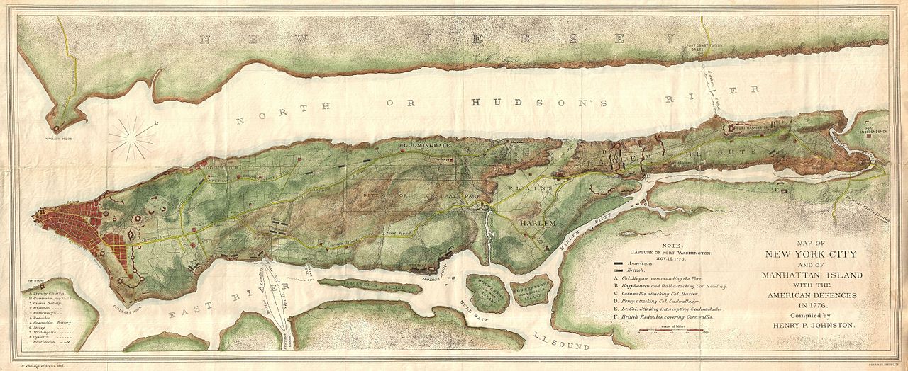
 1878 Bien and Johnson Map of New York City (Manhattan Island) During the Revolutionary War - Geographicus - NewYorkCity-johnsonbien-1878
 Atlas of Battles of the American Revolution, Sheet 6: A Topographical Map of the Northn. Part of New York Island, Exhibiting the Plan of Fort Washington, now Fort Knyphausen, With the Rebels Lines to the Southward, which were Forced by the Troops under the Command of the Rt. Honble. Earl Percy, on the 16th. Novr. 1776, and Survey'd immediately after by Order of his Lordship


