Crookston Castle
From Warlike
Q1966112
Crookston Castle is a ruined medieval castle in the Pollok area of Glasgow, Scotland. It is located some five miles south-west of the city centre, on a hill overlooking the Levern Water, just before its confluence with the White Cart Water. Crookston Castle was built by the Stewarts of Darnley around 1400, and is set within earthworks constructed in the 12th century. Once the property of the earls and dukes of Lennox, the castle was extensively repaired following a siege in 1544, and it is the only surviving medieval castle in Glasgow.
1180 Website,
Wikimedia, Wikidata
United Kingdom, United Kingdom, 
- Historic Environment Scotland page@
- Historic Environment Scotland page@
- Canmore page@
- CastlesFortsBattles page@
- Tripadvisor page@
Location: 55.835, -4.3558, KML, Cluster Map, Maps, ![]()
![]()
39 places
-

Battle of Alclud Ford ⓘ
580 battle -
Siege of Dumbarton ⓘ
870 siege of Dumbarton by Vikings -
Battle of Renfrew ⓘ
1164 battle near Renfrew, Scotland -

Battle of Loudoun Hill ⓘ
1307 Medieval battle -

Battle of Glasgow ⓘ
1544 battle on Glasgow Muir, Scotland, as part of the Rough Wooing -
Battle of Glasgow ⓘ
1560 battle between French troops and forces of the Scottish Reformation -

Battle of Langside ⓘ
1568 opening battle of the Marian civil war in Scotland -

Battle of Kilsyth ⓘ
1645 battle -
Battle of Hieton ⓘ
battle during the Anglo-Scottish war of 1650–1652 -

Battle of Drumclog ⓘ
1679 battle of the Scottish Covenanter Wars -

Battle of Bothwell Bridge ⓘ
1679 musical work/composition -
Clydebank Blitz ⓘ
1941 WWII aerial bombardment of city in Scotland -
Greenock Blitz ⓘ
German bombing raids on Greenock, Scotland during WW2 -
Drumbowie Farm anti-aircraft battery ⓘ
site of anti-aircraft battery 350m WSW of Drumbowie Farm in North Lanarkshire, Scotland, UK -
Gryffe Wraes Cottage, anti-aircraft site 185m WNW of ⓘ
architectural structure in Renfrewshire, Scotland, UK -
High Mathernock, AA battery 350m WSW and camp 360 SW of ⓘ
architectural structure in Inverclyde, Scotland, UK -
Steel Cottage, anti-aircraft battery 480m NW of ⓘ
architectural structure in Renfrewshire, Scotland, UK -
East Kilbride Regional War Room ⓘ
bunker in South Lanarkshire, Scotland, UK -
Strathclyde Regional Council - Dumbarton Emergency Headquarters - Garshake ⓘ
civil defence centre in Strathclyde, UK -
Strathclyde Regional Council - Dumbarton Emergency Headquarters - Crosslet ⓘ
civil defence centre in Strathclyde, UK -
Torrance House Anti-Aircraft Operations Room ⓘ
British air defence bunker -

Barony and Castle of Kilbirnie ⓘ
tower house in Kilbirnie, North Ayrshire, Scotland, UK
-

Barr Castle ⓘ
late medieval tower house in Lochwinnoch, Renfrewshire, Scotland, UK 
-

Cadzow Castle ⓘ
castle in South Lanarkshire, Scotland, UK -

Caldwell Tower ⓘ
tower in East Renfrewshire, Scotland, UK -

Castle Semple ⓘ
castle in Renfrewshire, Scotland, UK -

Cathcart Castle ⓘ
castle in Glasgow City, Scotland, UK -

Dalzell House ⓘ
castle in North Lanarkshire, Scotland, UK -

Dumbarton Castle ⓘ
castle in West Dunbartonshire, Scotland, UK -

Lennox Castle ⓘ
castle and former hospital in East Dunbartonshire, Scotland, UK -
Lennox Castle ⓘ
castle in East Dunbartonshire, Scotland, UK -

Mearns Castle ⓘ
castle in East Renfrewshire, Scotland, UK -

Mugdock Castle ⓘ
castle with associated chapel and house, all ruins, in Stirling, Scotland, UK -

Strathaven Castle ⓘ
castle in South Lanarkshire, Scotland, UK -

Crookston Castle ⓘ
ringwork castle in Glasgow City, Scotland, UK -

Kilmahew Castle ⓘ
castle in Argyll and Bute, Scotland, UK -

Dean Castle ⓘ
castle and museum in East Ayrshire, Scotland, United Kingdom -

Glenlee ⓘ
1896 steel-hulled three-masted barque and museum in Glasgow, Scotland, United Kingdom -
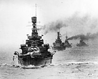
HMS Repulse ⓘ
1916 Renown-class battlecruiser
1180-01-01T00:00:00Z
1180-01-01T00:00:00Z
1180 Crookston Castle
1997-01-01T00:00:00Z
1997-01-01T00:00:00Z
geophysical survey
1973-01-01T00:00:00Z
1973-01-01T00:00:00Z
archaeological excavation
{"selectable":false,"showCurrentTime":false,"width":"100%","zoomMin":100000000000}
 Jacobite broadside - Reproduction of an engraving of Cruikston Castle, with a reproduction of Burns' inscription on the Crookston Yew on verso
 View South-westwards from Crookston Castle
 Crookston Castle engraving by William Miller after G F Sargent
 Crookston Castle vignette engraving by William Miller after G F Sargent
 Crookston Castle in 1900
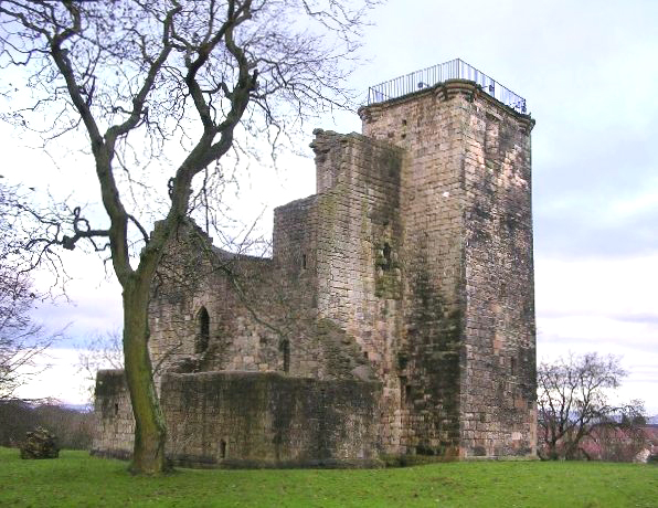 Crookston Castle
 Crookston Castle
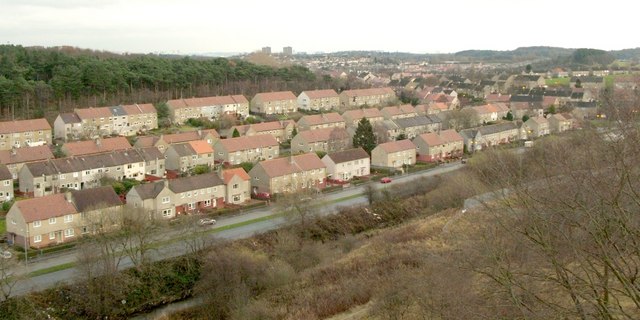 View from Crookston Castle - ENE
 Defensive ditch of Crookston Castle
 Defensive ditch, from top of Crookston Castle
- Excavations at Crookston Castle, Glasgow 1973–75 - article by John Lewis published March 2003 in Scottish Archaeological Journal
| Type | Subtype | Date | Description | Notes | Source |
|---|---|---|---|---|---|
| event | armed conflict | 580 | Battle of Alclud Ford | Kingdom of Bernicia, Kingdom of Rheged, battle | Wikidata |
| event | armed conflict | 870 | Siege of Dumbarton | siege | Wikidata |
| event | armed conflict | 1164 | Battle of Renfrew | battle | Wikidata |
| event | armed conflict | 1307 | Battle of Loudoun Hill | battle | Wikidata |
| event | armed conflict | 1544 | Battle of Glasgow | battle | Wikidata |
| event | armed conflict | 1560 | Battle of Glasgow | battle | Wikidata |
| event | armed conflict | 1568 | Battle of Langside | battle, Kingdom of Scotland | Wikidata |
| event | armed conflict | 1645 | Battle of Kilsyth | battle, Covenanters, Confederate Ireland, Cavalier | Wikidata |
| event | armed conflict | 1650 | Battle of Hieton | battle, Commonwealth of England | Wikidata |
| event | armed conflict | 1679 | Battle of Drumclog | battle | Wikidata |
| event | armed conflict | 1679 | Battle of Bothwell Bridge | battle, ballad, musical work/composition | Wikidata |
| event | armed conflict | 1941 | Clydebank Blitz | Nazi Germany, battle | Wikidata |
| event | armed conflict | 1941 | Greenock Blitz | Nazi Germany, aerial bombing of a city | Wikidata |
| link | page | Historic Environment Scotland page@ | Wikidata | ||
| link | page | Historic Environment Scotland page@ | Wikidata | ||
| link | page | Canmore page@ | Wikidata | ||
| link | page | CastlesFortsBattles page@ | Wikidata | ||
| link | page | Tripadvisor page@ | Wikidata | ||
| object | watercraft | 1933 | Maillé Brézé | destroyer, Vauquelin-class destroyer | Wikidata |
| organisation | arms industry | A. & J. Inglis | arms industry, shipbuilding, shipbuilding company | Wikidata | |
| organisation | arms industry | Scottish Iron and Steel Company | arms industry, business | Wikidata | |
| organisation | arms industry | 2008 | BAE Systems Maritime – Naval Ships | arms industry, business | Wikidata |
| organisation | factory | 1750 | Alexander Stephen and Sons | shipyard, business, shipbuilding | Wikidata |
| organisation | factory | 1834 | Fairfield Shipbuilding and Engineering Company | shipyard, shipbuilding, public company, vehicle construction | Wikidata |
| organisation | factory | 1837 | William Beardmore and Company | automotive industry, shipyard, business, locomotive manufacturing, shipbuilding, automobile manufacturer, metal industry, commercial organization, machinery industry and plant construction | Wikidata |
| organisation | factory | 1861 | Charles Connell and Company | shipyard, shipbuilding, business | Wikidata |
| organisation | factory | 1865 | Yarrow Shipbuilders Limited | shipyard, shipbuilding, business, enterprise, manufacture of steam generators, except central heating hot water boilers, Manufacture of military fighting vehicles | Wikidata |
| organisation | factory | 1988 | Kvaerner Govan | shipyard, shipbuilding, business | Wikidata |
| organisation | shipbuilding | 1840 | William Denny and Brothers | shipbuilding, business | Wikidata |
| organisation | shipbuilding | 1967 | Scott Lithgow | shipbuilding, business | Wikidata |
| organisation | shipbuilding | 1968 | Upper Clyde Shipbuilders | shipbuilding, business | Wikidata |
| organisation | shipbuilding company | Blackwood and Gordon | shipbuilding company | Wikidata | |
| organisation | shipbuilding company | Greenock Dockyard Company | shipbuilding company | Wikidata | |
| organisation | shipbuilding company | William Hamilton and Company | shipbuilding company | Wikidata | |
| organisation | shipbuilding company | 1711 | Scotts Shipbuilding and Engineering Company | shipbuilding, shipbuilding company | Wikidata |
| organisation | shipbuilding company | 1826 | Robert Napier and Sons | shipbuilding, engineering activities and related technical consultancy, shipbuilding company | Wikidata |
| organisation | shipbuilding company | 1830 | Robert Duncan and Co. | shipbuilding, shipbuilding company | Wikidata |
| organisation | shipbuilding company | 1851 | John Brown & Company | shipbuilding, enterprise, shipbuilding company, business, machinery industry and plant construction | Wikidata |
| organisation | shipbuilding company | 1860 | Lobnitz | shipbuilding, shipbuilding company | Wikidata |
| organisation | shipbuilding company | 1872 | D. and W. Henderson and Company | shipbuilding, shipbuilding company | Wikidata |
| organisation | shipbuilding company | 1874 | Lithgows | shipbuilding, shipbuilding company | Wikidata |
| organisation | shipbuilding company | 1898 | Napier and Miller | shipbuilding company | Wikidata |
| organisation | shipbuilding company | 1903 | Ferguson Marine Engineering | shipbuilding, shipbuilding company | Wikidata |
| organisation | shipbuilding company | 1999 | BAE Systems Marine | shipbuilding, business, shipbuilding company | Wikidata |
| site | artillery battery | Drumbowie Farm anti-aircraft battery | anti-aircraft battery | Wikidata | |
| site | artillery battery | Gryffe Wraes Cottage, anti-aircraft site 185m WNW of | anti-aircraft battery | Wikidata | |
| site | artillery battery | High Mathernock, AA battery 350m WSW and camp 360 SW of | anti-aircraft battery | Wikidata | |
| site | artillery battery | Steel Cottage, anti-aircraft battery 480m NW of | artillery battery | Wikidata | |
| site | bunker | East Kilbride Regional War Room | bunker | Wikidata | |
| site | bunker | Strathclyde Regional Council - Dumbarton Emergency Headquarters - Garshake | civil defense center, Strathclyde Regional Council | Wikidata | |
| site | bunker | Strathclyde Regional Council - Dumbarton Emergency Headquarters - Crosslet | civil defense center, Strathclyde Regional Council | Wikidata | |
| site | bunker | Torrance House Anti-Aircraft Operations Room | Royal Air Force, bunker | Wikidata | |
| site | castle | Barony and Castle of Kilbirnie | tower house, castle | Wikidata | |
| site | castle | Barr Castle | castle | Wikidata | |
| site | castle | Cadzow Castle | archaeological site, castle | Wikidata | |
| site | castle | Caldwell Tower | tower house | Wikidata | |
| site | castle | Castle Semple | castle | Wikidata | |
| site | castle | Cathcart Castle | tower house, ringwork castle | Wikidata | |
| site | castle | Dalzell House | castle | Wikidata | |
| site | castle | Dumbarton Castle | contour fort, Historic Environment Scotland, castle | Wikidata | |
| site | castle | Lennox Castle | castle, former hospital | Wikidata | |
| site | castle | Lennox Castle | country house, castle | Wikidata | |
| site | castle | Mearns Castle | castle | Wikidata | |
| site | castle | Mugdock Castle | castle | Wikidata | |
| site | castle | Strathaven Castle | castle | Wikidata | |
| site | castle | 1180 | Crookston Castle | Historic Environment Scotland, ringwork castle, archaeological site, tower house | Wikidata |
| site | castle | 1290 | Kilmahew Castle | Clan Napier, castle | Wikidata |
| site | castle | 1350 | Dean Castle | local authority museum, military museum, castle | Wikidata |
| site | museum | 1896 | Glenlee | preserved watercraft, independent museum, barque, museum ship, tripadvisor | Wikidata |
| site | shipwreck | 1916 | HMS Repulse | Renown-class battlecruiser, shipwreck, battlecruiser | Wikidata |
| commons | image | Jacobite broadside - Reproduction of an engraving of Cruikston Castle, with a reproduction of Burns' inscription on the Crookston Yew on verso | Commons | ||
| commons | image | View South-westwards from Crookston Castle | Commons | ||
| commons | image | Crookston Castle engraving by William Miller after G F Sargent | Commons | ||
| commons | image | Crookston Castle vignette engraving by William Miller after G F Sargent | Commons | ||
| commons | image | Crookston Castle in 1900 | Commons | ||
| commons | image | Crookston Castle | Commons | ||
| commons | image | Crookston Castle | Commons | ||
| commons | image | View from Crookston Castle - ENE | Commons | ||
| commons | image | Defensive ditch of Crookston Castle | Commons | ||
| commons | image | Defensive ditch, from top of Crookston Castle | Commons | ||