Lohagad
From Warlike
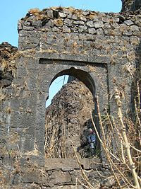
Lohagad is one of the many hill forts of Maharashtra state in India. Situated close to the hill station Lonavala and 52 km (32 mi) northwest of Pune, Lohagad rises to an elevation of 1,033 m (3,389 ft) above sea level. The fort is connected to the neighboring Visapur fort by a small range. The fort was under the Lohtamia empire for the majority of the time, with a short period of 5 years under the Mughal Empire.
Wikimedia, Wikidata
Iron Fort, Malavli; Loha Gadh; Lohagadh; Lohgad
India, India, 
-
Location: 18.7099, 73.4764, KML, Cluster Map, Maps,
11 places
-

Battle of Wadgaon ⓘ
1779 battle in India -

Ghangad ⓘ
-

Indori Fort ⓘ
fort in Pune district, India -

Korigad ⓘ
hill fort in Pune district, Maharashtra -

Lohagad ⓘ
fort in Pune district, Maharashtra, India -
Manaranjan Fort ⓘ
-

Rajmachi Fort ⓘ
fort in Maharashtra, India -

Shrivardhan Fort ⓘ
hill Fort in Maharashtra, India -

Tikona ⓘ
fort in Pune district, Maharashtra, India -
Tung Fort ⓘ
hill fort in Maharashtra, India -

Visapur Fort ⓘ
fort in Pune district, Maharashtra, India
{"selectable":false,"showCurrentTime":false,"width":"100%","zoomMin":100000000000}
 Sightseeing in Pune 2016 Pic116
 Misty mountain top - Lohagad Fort
 Naturalis Biodiversity Center - ZMA.MAM.9786.a lat - Hipposideros speoris - skull
 Naturalis Biodiversity Center - ZMA.MAM.9786.a pal - Hipposideros speoris - skull
 Lohagad
 Bastions of Lohagad Fort 7
 Bastions of Lohagad Fort 3
 Panoramic view of the bastions of Lohagad Fort 3
 Bastions of Lohagad Fort 2
 Panoramic view of the bastions of Lohagad Fort 2