Fort Kaministiquia
From Warlike
Fort Kaministiquia, was a French fort in North America. It was located on the north shore of Lake Superior at the mouth of the Kaministiquia River, in modern-day Thunder Bay, Ontario, Canada. It and Grand Portage to the west were the starting points of the early Canadian canoe routes from the Great Lakes to western Canada. Details of the route can be found under Kaministiquia River.

-
Location: 48.3933, -89.2397, KML, Cluster Map, Maps,
-

Fort Kaministiquia ⓘ
French fort in North America
 Cartes extraites de - Considérations géographiques et physiques sur les nouvelles découvertes au nord de la Grande Mer appelée vulgairement la Mer du Sud. .. - par Philippe Buache... - btv1b53177671p (1 of 9)
 Cours des rivières, et fleuves, courant à l'ouest du nord du Lac Supérieur, suivant la carte faite par le sauvage Ochagac et autres, reduite dans celle cy sur une meme Echelle. .. - btv1b53052645m
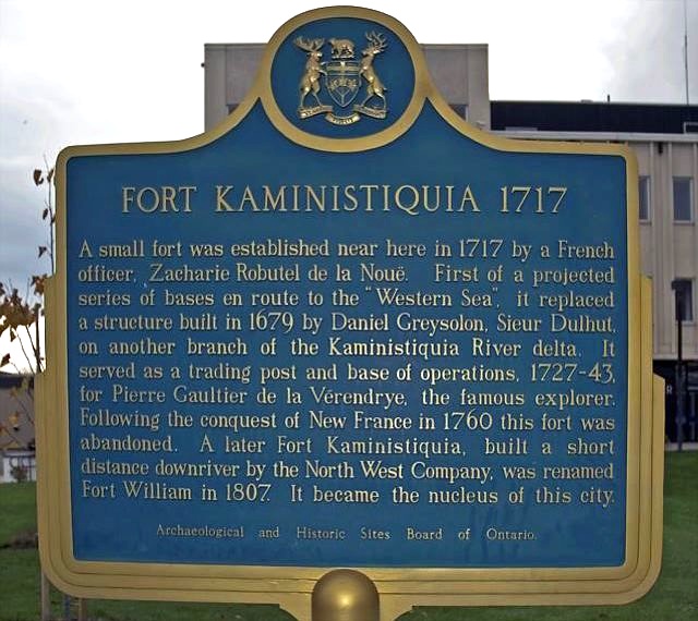 Fort Kaministiquia
 Fort Kaministiquia Old Fort William
| Type | Subtype | Date | Description | Notes | Source |
|---|---|---|---|---|---|
| timelineTypessite,event | |||||
| timelineArrayArray | |||||
| organisation | shipbuilding | 1909 | Western Dry Dock and Shipbuilding Company | shipbuilding, company | Wikidata |
| site | fort | 1717 | Fort Kaministiquia | fort | Wikidata |
| commons | image | Cartes extraites de - Considérations géographiques et physiques sur les nouvelles découvertes au nord de la Grande Mer appelée vulgairement la Mer du Sud. .. - par Philippe Buache... - btv1b53177671p (1 of 9) | Commons | ||
| commons | image | Cours des rivières, et fleuves, courant à l'ouest du nord du Lac Supérieur, suivant la carte faite par le sauvage Ochagac et autres, reduite dans celle cy sur une meme Echelle. .. - btv1b53052645m | Commons | ||
| commons | image | Fort Kaministiquia | Commons | ||
| commons | image | Fort Kaministiquia Old Fort William | Commons | ||
.jpg)