Fort Brown
From Warlike
Fort Brown was a military post of the United States Army in Cameron County, Texas, during the latter half of the 19th century and the early part of the 20th century. Established in 1846, it was the first US Army military outpost of the recently annexed state. Confederate Army troops stationed there saw action during the American Civil War. In the early 20th century, it was garrisoned in relation to military activity over border conflicts with Mexico. Surviving elements of the fort were designated as a National Historic Landmark in 1960.
Wikimedia, Wikidata
United States, United States, 
- National Register of Historic Places listed place page@
- National Register of Historic Places page@
- Texas Historic Sites Atlas page@
- FortWiki page@
Location: 25.8862, -97.4941, KML, Cluster Map, Maps,
8 places
-

Battle of Brownsville ⓘ
battle of the American Civil War -
Battle of Matamoros ⓘ
1836 naval engagement of the Texas Revolution -

Siege of Fort Texas ⓘ
1846 A war -
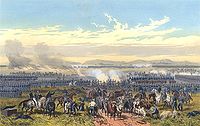
Battle of Palo Alto ⓘ
1846 battle of the Mexican-American War -

Battle of Resaca de la Palma ⓘ
1846 battle of the Mexican–American War -

Battle of Palmito Ranch ⓘ
1865 American Civil War battle -

Fort Brown ⓘ
Texas, a former US Amy post -

Fuerte Castamata ⓘ
fort museum: figured in Mexican Revolution
1836-04-03T00:00:00Z
1836-04-03T00:00:00Z
{"selectable":false,"showCurrentTime":false,"width":"100%","zoomMin":100000000000}
 Map of the Post of Fort Brown Brownsville, Texas - NARA - 122668604
 A Portion of Fort Brown Military Reservation, Texas showing present Location of the River Bank at the points where the River is cutting - DPLA - da352b745385e6942bd2472a22139584 (page 2)
 Map of the Post of Fort Brown, Brownsville, Texas - NARA - 122668600
 Map of the Post of Fort Brown Brownsville, Texas - NARA - 122668602
 A Portion of Fort Brown Military Reservation, Texas showing present Location of the River Bank at the points where the River is cutting - DPLA - da352b745385e6942bd2472a22139584 (page 1)
 Map of Fort Brown, Texas - NARA - 137930210
 Details of Sewer System, Fort Brown, Texas - DPLA - 00861207be7302752b5d38a8f095cee1 (page 3)
 Details of Sewer System, Fort Brown, Texas - DPLA - 00861207be7302752b5d38a8f095cee1 (page 1)
 Alteration to Quarters No. 44, Fort Brown, Texas - DPLA - bcea7253bdf2447da910a75d30777ec2
 Details of Sewer System, Fort Brown, Texas - DPLA - 00861207be7302752b5d38a8f095cee1 (page 2)
.jpg)
.jpg)
.jpg)
.jpg)
.jpg)