Duncraig Castle
From Warlike
Q15618499
Duncraig Castle is a mansion in Lochalsh, in the west of the Scottish Highlands. A category-C listed building, it is situated in the Highland council area, east of the village of Plockton on the south shore of Loch Carron. It was built in 1866 in the Scottish baronial style, to designs by Alexander Ross, for Scottish Member of Parliament and businessman Alexander Matheson. The castle remained in the Matheson family until the 1920s, when it was sold to Sir Daniel Hamilton and his wife Margaret, who owned the neighbouring estate. The Hamiltons intended to use the castle for educational purposes in the local community, but this never came to fruition and following the outbreak of World War II, the castle was used as a naval hospital. By the end of the war, Daniel Hamilton had died, and Margaret bequeathed the castle to the local council, which converted it for use as a home economics college for girls, operating in this capacity until its closure in 1989.
Wikimedia, Wikidata
United Kingdom, United Kingdom, .jpg)
- Cultural Inventory page@
- Tripadvisor page@
Location: 57.338, -5.6335, KML, Cluster Map, Maps, ![]()
![]()
9 places
-

Battle of Achnashellach ⓘ
1505 Scottish clan battle -

Battle of Glen Shiel ⓘ
battle in Highland, Scotland, UK -

Battle of Coille Bhan ⓘ
battle at the height of the 1719 Jacobite Rising -

Raasay House, cross-incised slab & battery 310m SW of, Raasay ⓘ
architectural structure in Highland, Scotland, UK -

Brochel Castle ⓘ
castle ruin

-

Caisteal Maol ⓘ
castle in Highland, Scotland, UK -

Duncraig Castle ⓘ
castle in Highland, Scotland, UK -

Eilean Donan Castle ⓘ
castle in Highland, Scotland, UK -

HMS Port Napier ⓘ
1940 minelayer destroyed in Loch Alsh, Scotland, by an explosion following an engine room fire
 Nautical chart of Loch Kishorn and the approaches to Loch Carron
 Plockton Bay
 Tumbled Mountains
 View from Minvaugh toward Duncraig Castle
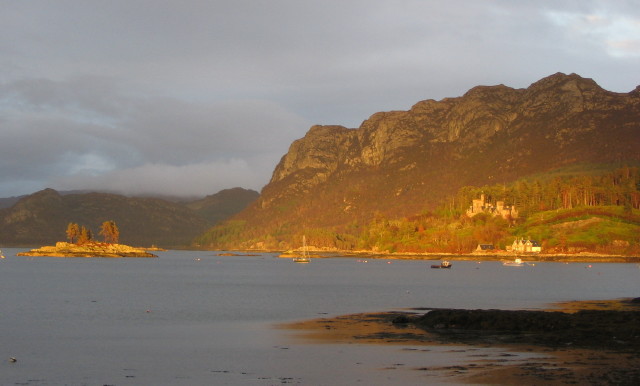 Duncraig Castle and Sgeir Bhuidhe
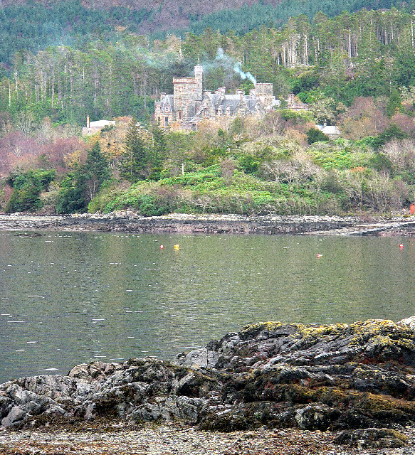 Duncraig Castle, Plockton
 Duncraig Castle from Plockton
 New Pontoon
 Duncraig Castle
 Duncraig Castle from Plockton
| Type | Subtype | Date | Description | Notes | Source |
|---|---|---|---|---|---|
| event | armed conflict | 1505 | Battle of Achnashellach | battle | Wikidata |
| event | armed conflict | 1719 | Battle of Glen Shiel | Kingdom of Great Britain, battle, Jacobitism, Kingdom of Spain | Wikidata |
| event | armed conflict | 1721 | Battle of Coille Bhan | Kingdom of Great Britain, Jacobitism, battle | Wikidata |
| link | page | Cultural Inventory page@ | Wikidata | ||
| link | page | Tripadvisor page@ | Wikidata | ||
| site | artillery battery | Raasay House, cross-incised slab & battery 310m SW of, Raasay | artillery battery | Wikidata | |
| site | castle | Brochel Castle | castle | Wikidata | |
| site | castle | Caisteal Maol | tower house | Wikidata | |
| site | castle | Duncraig Castle | castle | Wikidata | |
| site | castle | Eilean Donan Castle | castle | Wikidata | |
| site | shipwreck | HMS Port Napier | shipwreck, minelayer | Wikidata | |
| commons | image | Nautical chart of Loch Kishorn and the approaches to Loch Carron | Commons | ||
| commons | image | Plockton Bay | Commons | ||
| commons | image | Tumbled Mountains | Commons | ||
| commons | image | View from Minvaugh toward Duncraig Castle | Commons | ||
| commons | image | Duncraig Castle and Sgeir Bhuidhe | Commons | ||
| commons | image | Duncraig Castle, Plockton | Commons | ||
| commons | image | Duncraig Castle from Plockton | Commons | ||
| commons | image | New Pontoon | Commons | ||
| commons | image | Duncraig Castle | Commons | ||
| commons | image | Duncraig Castle from Plockton | Commons | ||