Loading map...
{"minzoom":false,"maxzoom":false,"mappingservice":"leaflet","width":"auto","height":"600px","centre":false,"title":"","label":"","icon":"","lines":[],"polygons":[],"circles":[],"rectangles":[],"copycoords":false,"static":false,"zoom":false,"defzoom":14,"layers":["OpenStreetMap","Esri.WorldImagery"],"image layers":[],"overlays":[],"resizable":false,"fullscreen":true,"scrollwheelzoom":true,"cluster":false,"clustermaxzoom":20,"clusterzoomonclick":true,"clustermaxradius":1,"clusterspiderfy":true,"geojson":"","clicktarget":"","imageLayers":[],"locations":[{"text":"\u003Cb\u003E\u003Cdiv class=\"mw-parser-output\"\u003E\u003Cp\u003ERAF Goxhill\u003C/b\u003E\u003Cdiv class=\"mw-parser-output\"\u003E\u003Cp\u003Eformer Air Force station\n\u003C/p\u003E\u003C/div\u003E","title":"RAF Goxhill@former Air Force station\n","link":"","lat":53.6778,"lon":-0.315556,"icon":"/images/d/d2/Red-marker.png"},{"text":"\u003Cb\u003E\u003Cdiv class=\"mw-parser-output\"\u003E\u003Cp\u003E\u003Ca href=\"/Q38251550\" title=\"Q38251550\"\u003ELondesborough Barracks\u003C/a\u003E\u003C/b\u003E\u003Cdiv class=\"mw-parser-output\"\u003E\u003Cp\u003Ebarracks\n\u003C/p\u003E\u003C/div\u003E","title":"Londesborough Barracks@ barracks\n","link":"","lat":53.7463,"lon":-0.35457,"icon":"/images/1/14/M_base.png"},{"text":"\u003Cb\u003E\u003Cdiv class=\"mw-parser-output\"\u003E\u003Cp\u003E\u003Ca href=\"/Q21061710\" title=\"Q21061710\"\u003ENorth Killingholme Haven\u003C/a\u003E\u003C/b\u003E\u003Cdiv class=\"mw-parser-output\"\u003E\u003Cp\u003Eharbor, Royal Naval Air Service station\n\u003C/p\u003E\u003C/div\u003E","title":"North Killingholme Haven@ harbor, Royal Naval Air Service station\n","link":"","lat":53.664,"lon":-0.235052,"icon":"/images/1/14/M_base.png"},{"text":"\u003Cb\u003E\u003Cdiv class=\"mw-parser-output\"\u003E\u003Cp\u003E\u003Ca href=\"/Q138896\" title=\"Q138896\"\u003ERAF Binbrook\u003C/a\u003E\u003C/b\u003E\u003Cdiv class=\"mw-parser-output\"\u003E\u003Cp\u003ERoyal Air Force, air base, Royal Air Force station\n\u003C/p\u003E\u003C/div\u003E","title":"RAF Binbrook@ Royal Air Force, air base, Royal Air Force station\n","link":"","lat":53.446,"lon":-0.208727,"icon":"/images/1/14/M_base.png"},{"text":"\u003Cb\u003E\u003Cdiv class=\"mw-parser-output\"\u003E\u003Cp\u003E\u003Ca href=\"/Q65078331\" title=\"Q65078331\"\u003ERAF Bridlington\u003C/a\u003E\u003C/b\u003E\u003Cdiv class=\"mw-parser-output\"\u003E\u003Cp\u003ERoyal Air Force, air base, Royal Air Force station\n\u003C/p\u003E\u003C/div\u003E","title":"RAF Bridlington@ Royal Air Force, air base, Royal Air Force station\n","link":"","lat":54.0796,"lon":-0.196268,"icon":"/images/1/14/M_base.png"},{"text":"\u003Cb\u003E\u003Cdiv class=\"mw-parser-output\"\u003E\u003Cp\u003E\u003Ca href=\"/Q7275211\" title=\"Q7275211\"\u003ERAF Caistor\u003C/a\u003E\u003C/b\u003E\u003Cdiv class=\"mw-parser-output\"\u003E\u003Cp\u003Eaerodrome, Royal Air Force, air base, launch and/or landing site, Royal Air Force station\n\u003C/p\u003E\u003C/div\u003E","title":"RAF Caistor@ aerodrome, Royal Air Force, air base, launch and/or landing site, Royal Air Force station\n","link":"","lat":53.5029,"lon":-0.364052,"icon":"/images/1/14/M_base.png"},{"text":"\u003Cb\u003E\u003Cdiv class=\"mw-parser-output\"\u003E\u003Cp\u003E\u003Ca href=\"/Q7275215\" title=\"Q7275215\"\u003ERAF Cammeringham\u003C/a\u003E\u003C/b\u003E\u003Cdiv class=\"mw-parser-output\"\u003E\u003Cp\u003ERoyal Air Force, air base, Royal Air Force station\n\u003C/p\u003E\u003C/div\u003E","title":"RAF Cammeringham@ Royal Air Force, air base, Royal Air Force station\n","link":"","lat":53.3411,"lon":-0.554784,"icon":"/images/1/14/M_base.png"},{"text":"\u003Cb\u003E\u003Cdiv class=\"mw-parser-output\"\u003E\u003Cp\u003E\u003Ca href=\"/Q7275218\" title=\"Q7275218\"\u003ERAF Carnaby\u003C/a\u003E\u003C/b\u003E\u003Cdiv class=\"mw-parser-output\"\u003E\u003Cp\u003ERoyal Air Force, air base, Royal Air Force station\n\u003C/p\u003E\u003C/div\u003E","title":"RAF Carnaby@ Royal Air Force, air base, Royal Air Force station\n","link":"","lat":54.0607,"lon":-0.261907,"icon":"/images/1/14/M_base.png"},{"text":"\u003Cb\u003E\u003Cdiv class=\"mw-parser-output\"\u003E\u003Cp\u003E\u003Ca href=\"/Q7275224\" title=\"Q7275224\"\u003ERAF Catfoss\u003C/a\u003E\u003C/b\u003E\u003Cdiv class=\"mw-parser-output\"\u003E\u003Cp\u003ERoyal Air Force, air base, Royal Air Force station\n\u003C/p\u003E\u003C/div\u003E","title":"RAF Catfoss@ Royal Air Force, air base, Royal Air Force station\n","link":"","lat":53.921,"lon":-0.274887,"icon":"/images/1/14/M_base.png"},{"text":"\u003Cb\u003E\u003Cdiv class=\"mw-parser-output\"\u003E\u003Cp\u003E\u003Ca href=\"/Q7275254\" title=\"Q7275254\"\u003ERAF Cottam\u003C/a\u003E\u003C/b\u003E\u003Cdiv class=\"mw-parser-output\"\u003E\u003Cp\u003ERoyal Air Force, air base, Royal Air Force station\n\u003C/p\u003E\u003C/div\u003E","title":"RAF Cottam@ Royal Air Force, air base, Royal Air Force station\n","link":"","lat":54.0634,"lon":-0.483207,"icon":"/images/1/14/M_base.png"},{"text":"\u003Cb\u003E\u003Cdiv class=\"mw-parser-output\"\u003E\u003Cp\u003E\u003Ca href=\"/Q92094806\" title=\"Q92094806\"\u003ERAF Cowden\u003C/a\u003E\u003C/b\u003E\u003Cdiv class=\"mw-parser-output\"\u003E\u003Cp\u003ERoyal Air Force, air base, Royal Air Force station\n\u003C/p\u003E\u003C/div\u003E","title":"RAF Cowden@ Royal Air Force, air base, Royal Air Force station\n","link":"","lat":53.8443,"lon":-0.117867,"icon":"/images/1/14/M_base.png"},{"text":"\u003Cb\u003E\u003Cdiv class=\"mw-parser-output\"\u003E\u003Cp\u003E\u003Ca href=\"/Q7275284\" title=\"Q7275284\"\u003ERAF Driffield\u003C/a\u003E\u003C/b\u003E\u003Cdiv class=\"mw-parser-output\"\u003E\u003Cp\u003ERoyal Air Force, air base, Royal Air Force station\n\u003C/p\u003E\u003C/div\u003E","title":"RAF Driffield@ Royal Air Force, air base, Royal Air Force station\n","link":"","lat":53.9947,"lon":-0.486248,"icon":"/images/1/14/M_base.png"},{"text":"\u003Cb\u003E\u003Cdiv class=\"mw-parser-output\"\u003E\u003Cp\u003E\u003Ca href=\"/Q7275292\" title=\"Q7275292\"\u003ERAF Dunholme Lodge\u003C/a\u003E\u003C/b\u003E\u003Cdiv class=\"mw-parser-output\"\u003E\u003Cp\u003ERoyal Air Force, air base, Royal Air Force station\n\u003C/p\u003E\u003C/div\u003E","title":"RAF Dunholme Lodge@ Royal Air Force, air base, Royal Air Force station\n","link":"","lat":53.291,"lon":-0.50548,"icon":"/images/1/14/M_base.png"},{"text":"\u003Cb\u003E\u003Cdiv class=\"mw-parser-output\"\u003E\u003Cp\u003E\u003Ca href=\"/Q7275304\" title=\"Q7275304\"\u003ERAF Elsham Wolds\u003C/a\u003E\u003C/b\u003E\u003Cdiv class=\"mw-parser-output\"\u003E\u003Cp\u003ERoyal Air Force, air base, Royal Air Force station\n\u003C/p\u003E\u003C/div\u003E","title":"RAF Elsham Wolds@ Royal Air Force, air base, Royal Air Force station\n","link":"","lat":53.6066,"lon":-0.421705,"icon":"/images/1/14/M_base.png"},{"text":"\u003Cb\u003E\u003Cdiv class=\"mw-parser-output\"\u003E\u003Cp\u003E\u003Ca href=\"/Q7275309\" title=\"Q7275309\"\u003ERAF Faldingworth\u003C/a\u003E\u003C/b\u003E\u003Cdiv class=\"mw-parser-output\"\u003E\u003Cp\u003Eair base, Royal Air Force station, Royal Air Force\n\u003C/p\u003E\u003C/div\u003E","title":"RAF Faldingworth@ air base, Royal Air Force station, Royal Air Force\n","link":"","lat":53.3494,"lon":-0.456144,"icon":"/images/1/14/M_base.png"},{"text":"\u003Cb\u003E\u003Cdiv class=\"mw-parser-output\"\u003E\u003Cp\u003E\u003Ca href=\"/Q7275354\" title=\"Q7275354\"\u003ERAF Grimsby\u003C/a\u003E\u003C/b\u003E\u003Cdiv class=\"mw-parser-output\"\u003E\u003Cp\u003ERoyal Air Force, air base, Royal Air Force station\n\u003C/p\u003E\u003C/div\u003E","title":"RAF Grimsby@ Royal Air Force, air base, Royal Air Force station\n","link":"","lat":53.5033,"lon":-0.0822382,"icon":"/images/1/14/M_base.png"},{"text":"\u003Cb\u003E\u003Cdiv class=\"mw-parser-output\"\u003E\u003Cp\u003E\u003Ca href=\"/Q7275372\" title=\"Q7275372\"\u003ERAF Hemswell\u003C/a\u003E\u003C/b\u003E\u003Cdiv class=\"mw-parser-output\"\u003E\u003Cp\u003ERoyal Air Force, air base, Royal Flying Corps, Royal Air Force station\n\u003C/p\u003E\u003C/div\u003E","title":"RAF Hemswell@ Royal Air Force, air base, Royal Flying Corps, Royal Air Force station\n","link":"","lat":53.3989,"lon":-0.573793,"icon":"/images/1/14/M_base.png"},{"text":"\u003Cb\u003E\u003Cdiv class=\"mw-parser-output\"\u003E\u003Cp\u003E\u003Ca href=\"/Q7275376\" title=\"Q7275376\"\u003ERAF Hibaldstow\u003C/a\u003E\u003C/b\u003E\u003Cdiv class=\"mw-parser-output\"\u003E\u003Cp\u003Eaerodrome, Royal Air Force, air base, Royal Air Force station\n\u003C/p\u003E\u003C/div\u003E","title":"RAF Hibaldstow@ aerodrome, Royal Air Force, air base, Royal Air Force station\n","link":"","lat":53.497,"lon":-0.522885,"icon":"/images/1/14/M_base.png"},{"text":"\u003Cb\u003E\u003Cdiv class=\"mw-parser-output\"\u003E\u003Cp\u003E\u003Ca href=\"/Q7275383\" title=\"Q7275383\"\u003ERAF Holmpton\u003C/a\u003E\u003C/b\u003E\u003Cdiv class=\"mw-parser-output\"\u003E\u003Cp\u003Emilitary museum, Royal Air Force station, radar station, \u003Ca rel=\"nofollow\" class=\"external text\" href=\"https://www.tripadvisor.com/2627177\"\u003Etripadvisor\u003C/a\u003E\n\u003C/p\u003E\u003C/div\u003E","title":"RAF Holmpton@ military museum, Royal Air Force station, radar station, tripadvisor\n","link":"","lat":53.6838,"lon":-0.0672645,"icon":"tm_base.png"},{"text":"\u003Cb\u003E\u003Cdiv class=\"mw-parser-output\"\u003E\u003Cp\u003E\u003Ca href=\"/Q7275398\" title=\"Q7275398\"\u003ERAF Hutton Cranswick\u003C/a\u003E\u003C/b\u003E\u003Cdiv class=\"mw-parser-output\"\u003E\u003Cp\u003ERoyal Air Force, air base, Royal Air Force station\n\u003C/p\u003E\u003C/div\u003E","title":"RAF Hutton Cranswick@ Royal Air Force, air base, Royal Air Force station\n","link":"","lat":53.9491,"lon":-0.461962,"icon":"/images/1/14/M_base.png"},{"text":"\u003Cb\u003E\u003Cdiv class=\"mw-parser-output\"\u003E\u003Cp\u003E\u003Ca href=\"/Q7275412\" title=\"Q7275412\"\u003ERAF Kelstern\u003C/a\u003E\u003C/b\u003E\u003Cdiv class=\"mw-parser-output\"\u003E\u003Cp\u003ERoyal Air Force, air base, Royal Air Force station\n\u003C/p\u003E\u003C/div\u003E","title":"RAF Kelstern@ Royal Air Force, air base, Royal Air Force station\n","link":"","lat":53.41,"lon":-0.114983,"icon":"/images/1/14/M_base.png"},{"text":"\u003Cb\u003E\u003Cdiv class=\"mw-parser-output\"\u003E\u003Cp\u003E\u003Ca href=\"/Q7275422\" title=\"Q7275422\"\u003ERAF Kirmington\u003C/a\u003E\u003C/b\u003E\u003Cdiv class=\"mw-parser-output\"\u003E\u003Cp\u003Eaerodrome, Royal Air Force, air base, Royal Air Force station\n\u003C/p\u003E\u003C/div\u003E","title":"RAF Kirmington@ aerodrome, Royal Air Force, air base, Royal Air Force station\n","link":"","lat":53.5779,"lon":-0.34401,"icon":"/images/1/14/M_base.png"},{"text":"\u003Cb\u003E\u003Cdiv class=\"mw-parser-output\"\u003E\u003Cp\u003E\u003Ca href=\"/Q7275423\" title=\"Q7275423\"\u003ERAF Kirton in Lindsey\u003C/a\u003E\u003C/b\u003E\u003Cdiv class=\"mw-parser-output\"\u003E\u003Cp\u003ERoyal Air Force, air base, Royal Air Force station\n\u003C/p\u003E\u003C/div\u003E","title":"RAF Kirton in Lindsey@ Royal Air Force, air base, Royal Air Force station\n","link":"","lat":53.4612,"lon":-0.57829,"icon":"/images/1/14/M_base.png"},{"text":"\u003Cb\u003E\u003Cdiv class=\"mw-parser-output\"\u003E\u003Cp\u003E\u003Ca href=\"/Q7275431\" title=\"Q7275431\"\u003ERAF Leconfield\u003C/a\u003E\u003C/b\u003E\u003Cdiv class=\"mw-parser-output\"\u003E\u003Cp\u003ERoyal Air Force, air base, airport, Royal Air Force station\n\u003C/p\u003E\u003C/div\u003E","title":"RAF Leconfield@ Royal Air Force, air base, airport, Royal Air Force station\n","link":"","lat":53.8767,"lon":-0.437526,"icon":"/images/1/14/M_base.png"},{"text":"\u003Cb\u003E\u003Cdiv class=\"mw-parser-output\"\u003E\u003Cp\u003E\u003Ca href=\"/Q7275441\" title=\"Q7275441\"\u003ERAF Lissett\u003C/a\u003E\u003C/b\u003E\u003Cdiv class=\"mw-parser-output\"\u003E\u003Cp\u003ERoyal Air Force, air base, Royal Air Force station\n\u003C/p\u003E\u003C/div\u003E","title":"RAF Lissett@ Royal Air Force, air base, Royal Air Force station\n","link":"","lat":54.0052,"lon":-0.273225,"icon":"/images/1/14/M_base.png"},{"text":"\u003Cb\u003E\u003Cdiv class=\"mw-parser-output\"\u003E\u003Cp\u003E\u003Ca href=\"/Q91937341\" title=\"Q91937341\"\u003ERAF Market Stainton\u003C/a\u003E\u003C/b\u003E\u003Cdiv class=\"mw-parser-output\"\u003E\u003Cp\u003ERoyal Air Force, air base, Royal Air Force station\n\u003C/p\u003E\u003C/div\u003E","title":"RAF Market Stainton@ Royal Air Force, air base, Royal Air Force station\n","link":"","lat":53.3085,"lon":-0.15696,"icon":"/images/1/14/M_base.png"},{"text":"\u003Cb\u003E\u003Cdiv class=\"mw-parser-output\"\u003E\u003Cp\u003E\u003Ca href=\"/Q20981814\" title=\"Q20981814\"\u003ERAF North Coates\u003C/a\u003E\u003C/b\u003E\u003Cdiv class=\"mw-parser-output\"\u003E\u003Cp\u003ERoyal Air Force, air base, Royal Air Force station\n\u003C/p\u003E\u003C/div\u003E","title":"RAF North Coates@ Royal Air Force, air base, Royal Air Force station\n","link":"","lat":53.4998,"lon":0.0657922,"icon":"/images/1/14/M_base.png"},{"text":"\u003Cb\u003E\u003Cdiv class=\"mw-parser-output\"\u003E\u003Cp\u003E\u003Ca href=\"/Q7275503\" title=\"Q7275503\"\u003ERAF North Killingholme\u003C/a\u003E\u003C/b\u003E\u003Cdiv class=\"mw-parser-output\"\u003E\u003Cp\u003ERoyal Air Force, air base, Royal Air Force station\n\u003C/p\u003E\u003C/div\u003E","title":"RAF North Killingholme@ Royal Air Force, air base, Royal Air Force station\n","link":"","lat":53.6359,"lon":-0.292033,"icon":"/images/1/14/M_base.png"},{"text":"\u003Cb\u003E\u003Cdiv class=\"mw-parser-output\"\u003E\u003Cp\u003E\u003Ca href=\"/Q123280956\" title=\"Q123280956\"\u003ERAF Patrington\u003C/a\u003E\u003C/b\u003E\u003Cdiv class=\"mw-parser-output\"\u003E\u003Cp\u003ERoyal Air Force, Royal Air Force station, radar station\n\u003C/p\u003E\u003C/div\u003E","title":"RAF Patrington@ Royal Air Force, Royal Air Force station, radar station\n","link":"","lat":53.6631,"lon":-0.0380402,"icon":"/images/1/14/M_base.png"},{"text":"\u003Cb\u003E\u003Cdiv class=\"mw-parser-output\"\u003E\u003Cp\u003E\u003Ca href=\"/Q7275598\" title=\"Q7275598\"\u003ERAF Stenigot\u003C/a\u003E\u003C/b\u003E\u003Cdiv class=\"mw-parser-output\"\u003E\u003Cp\u003ERoyal Air Force, Royal Air Force station, radar station\n\u003C/p\u003E\u003C/div\u003E","title":"RAF Stenigot@ Royal Air Force, Royal Air Force station, radar station\n","link":"","lat":53.3268,"lon":-0.115762,"icon":"/images/1/14/M_base.png"},{"text":"\u003Cb\u003E\u003Cdiv class=\"mw-parser-output\"\u003E\u003Cp\u003E\u003Ca href=\"/Q24993858\" title=\"Q24993858\"\u003ERAF Sutton on Hull\u003C/a\u003E\u003C/b\u003E\u003Cdiv class=\"mw-parser-output\"\u003E\u003Cp\u003ERoyal Air Force, air base, Royal Air Force station\n\u003C/p\u003E\u003C/div\u003E","title":"RAF Sutton on Hull@ Royal Air Force, air base, Royal Air Force station\n","link":"","lat":53.7894,"lon":-0.322713,"icon":"/images/1/14/M_base.png"},{"text":"\u003Cb\u003E\u003Cdiv class=\"mw-parser-output\"\u003E\u003Cp\u003E\u003Ca href=\"/Q7275681\" title=\"Q7275681\"\u003ERAF Wickenby\u003C/a\u003E\u003C/b\u003E\u003Cdiv class=\"mw-parser-output\"\u003E\u003Cp\u003ERoyal Air Force, air base, Royal Air Force station\n\u003C/p\u003E\u003C/div\u003E","title":"RAF Wickenby@ Royal Air Force, air base, Royal Air Force station\n","link":"","lat":53.3171,"lon":-0.348778,"icon":"/images/1/14/M_base.png"},{"text":"\u003Cb\u003E\u003Cdiv class=\"mw-parser-output\"\u003E\u003Cp\u003E\u003Ca href=\"/Q19972074\" title=\"Q19972074\"\u003EVictoria Barracks, Beverley\u003C/a\u003E\u003C/b\u003E\u003Cdiv class=\"mw-parser-output\"\u003E\u003Cp\u003Emilitary base\n\u003C/p\u003E\u003C/div\u003E","title":"Victoria Barracks, Beverley@ military base\n","link":"","lat":53.8229,"lon":-0.442891,"icon":"/images/1/14/M_base.png"},{"text":"\u003Cb\u003E\u003Cdiv class=\"mw-parser-output\"\u003E\u003Cp\u003E\u003Ca href=\"/Q48816910\" title=\"Q48816910\"\u003EWenlock Barracks\u003C/a\u003E\u003C/b\u003E\u003Cdiv class=\"mw-parser-output\"\u003E\u003Cp\u003Ebarracks\n\u003C/p\u003E\u003C/div\u003E","title":"Wenlock Barracks@ barracks\n","link":"","lat":53.7439,"lon":-0.375481,"icon":"/images/1/14/M_base.png"},{"text":"\u003Cb\u003E\u003Cdiv class=\"mw-parser-output\"\u003E\u003Cp\u003E\u003Ca href=\"/Q124945228\" title=\"Q124945228\"\u003ESkirlaugh Holderness District Council Emergency Centre\u003C/a\u003E\u003C/b\u003E\u003Cdiv class=\"mw-parser-output\"\u003E\u003Cp\u003Ecivil defense center\n\u003C/p\u003E\u003C/div\u003E","title":"Skirlaugh Holderness District Council Emergency Centre@ civil defense center\n","link":"","lat":53.8428,"lon":-0.272377,"icon":"/images/6/6e/M_bunker.png"},{"text":"\u003Cb\u003E\u003Cdiv class=\"mw-parser-output\"\u003E\u003Cp\u003E\u003Ca href=\"/Q124823220\" title=\"Q124823220\"\u003EWawne Anti-Aircraft Operations Room\u003C/a\u003E\u003C/b\u003E\u003Cdiv class=\"mw-parser-output\"\u003E\u003Cp\u003Ebunker, Royal Air Force\n\u003C/p\u003E\u003C/div\u003E","title":"Wawne Anti-Aircraft Operations Room@ bunker, Royal Air Force\n","link":"","lat":53.8176,"lon":-0.344442,"icon":"/images/6/6e/M_bunker.png"},{"text":"\u003Cb\u003E\u003Cdiv class=\"mw-parser-output\"\u003E\u003Cp\u003E\u003Ca href=\"/Q7535837\" title=\"Q7535837\"\u003ESkipsea Castle\u003C/a\u003E\u003C/b\u003E\u003Cdiv class=\"mw-parser-output\"\u003E\u003Cp\u003Emotte-and-bailey castle, English Heritage, \u003Ca rel=\"nofollow\" class=\"external text\" href=\"https://www.tripadvisor.com/10241342\"\u003Etripadvisor\u003C/a\u003E\n\u003C/p\u003E\u003C/div\u003E","title":"Skipsea Castle@ motte-and-bailey castle, English Heritage, tripadvisor\n","link":"","lat":53.9781,"lon":-0.230575,"icon":"/images/d/d5/Tm_castle.png"},{"text":"\u003Cb\u003E\u003Cdiv class=\"mw-parser-output\"\u003E\u003Cp\u003E\u003Ca href=\"/Q66477413\" title=\"Q66477413\"\u003EBull Sand Fort\u003C/a\u003E\u003C/b\u003E\u003Cdiv class=\"mw-parser-output\"\u003E\u003Cp\u003Esea fort\n\u003C/p\u003E\u003C/div\u003E","title":"Bull Sand Fort@ sea fort\n","link":"","lat":53.562,"lon":0.0679232,"icon":"/images/1/14/M_fort.png"},{"text":"\u003Cb\u003E\u003Cdiv class=\"mw-parser-output\"\u003E\u003Cp\u003E\u003Ca href=\"/Q17533434\" title=\"Q17533434\"\u003EFormer Heavy Anti-aircraft Gun Site\u003C/a\u003E\u003C/b\u003E\u003Cdiv class=\"mw-parser-output\"\u003E\u003Cp\u003Eanti-aircraft battery\n\u003C/p\u003E\u003C/div\u003E","title":"Former Heavy Anti-aircraft Gun Site@ anti-aircraft battery\n","link":"","lat":53.5886,"lon":-0.213439,"icon":"/images/1/14/M_fort.png"},{"text":"\u003Cb\u003E\u003Cdiv class=\"mw-parser-output\"\u003E\u003Cp\u003E\u003Ca href=\"/Q8564766\" title=\"Q8564766\"\u003EFort Paull\u003C/a\u003E\u003C/b\u003E\u003Cdiv class=\"mw-parser-output\"\u003E\u003Cp\u003Efort, military museum, \u003Ca rel=\"nofollow\" class=\"external text\" href=\"https://www.tripadvisor.com/607869\"\u003Etripadvisor\u003C/a\u003E\n\u003C/p\u003E\u003C/div\u003E","title":"Fort Paull@ fort, military museum, tripadvisor\n","link":"","lat":53.7129,"lon":-0.230071,"icon":"/images/1/12/Tm_fort.png"},{"text":"\u003Cb\u003E\u003Cdiv class=\"mw-parser-output\"\u003E\u003Cp\u003E\u003Ca href=\"/Q66477466\" title=\"Q66477466\"\u003EHaile Sand Fort\u003C/a\u003E\u003C/b\u003E\u003Cdiv class=\"mw-parser-output\"\u003E\u003Cp\u003Esea fort\n\u003C/p\u003E\u003C/div\u003E","title":"Haile Sand Fort@ sea fort\n","link":"","lat":53.5348,"lon":0.0342955,"icon":"/images/1/14/M_fort.png"},{"text":"\u003Cb\u003E\u003Cdiv class=\"mw-parser-output\"\u003E\u003Cp\u003E\u003Ca href=\"/Q17669142\" title=\"Q17669142\"\u003EHeavy Anti-aircraft gunsite 220m east of West Marsh Cottage\u003C/a\u003E\u003C/b\u003E\u003Cdiv class=\"mw-parser-output\"\u003E\u003Cp\u003Eanti-aircraft battery\n\u003C/p\u003E\u003C/div\u003E","title":"Heavy Anti-aircraft gunsite 220m east of West Marsh Cottage@ anti-aircraft battery\n","link":"","lat":53.6946,"lon":-0.401616,"icon":"/images/1/14/M_fort.png"},{"text":"\u003Cb\u003E\u003Cdiv class=\"mw-parser-output\"\u003E\u003Cp\u003E\u003Ca href=\"/Q17669292\" title=\"Q17669292\"\u003EHeavy Anti-aircraft gunsite at Old Ellerby, 600m south of Ellerby Grange\u003C/a\u003E\u003C/b\u003E\u003Cdiv class=\"mw-parser-output\"\u003E\u003Cp\u003Eanti-aircraft battery\n\u003C/p\u003E\u003C/div\u003E","title":"Heavy Anti-aircraft gunsite at Old Ellerby, 600m south of Ellerby Grange@ anti-aircraft battery\n","link":"","lat":53.8237,"lon":-0.231021,"icon":"/images/1/14/M_fort.png"},{"text":"\u003Cb\u003E\u003Cdiv class=\"mw-parser-output\"\u003E\u003Cp\u003E\u003Ca href=\"/Q17669374\" title=\"Q17669374\"\u003EHeavy Anti-aircraft gunsite, 350m west of Butt Farm\u003C/a\u003E\u003C/b\u003E\u003Cdiv class=\"mw-parser-output\"\u003E\u003Cp\u003Eanti-aircraft battery\n\u003C/p\u003E\u003C/div\u003E","title":"Heavy Anti-aircraft gunsite, 350m west of Butt Farm@ anti-aircraft battery\n","link":"","lat":53.819,"lon":-0.457455,"icon":"/images/1/14/M_fort.png"},{"text":"\u003Cb\u003E\u003Cdiv class=\"mw-parser-output\"\u003E\u003Cp\u003E\u003Ca href=\"/Q17663715\" title=\"Q17663715\"\u003EHeavy Anti-aircraft gunsite, 450m north east of Mere Farm\u003C/a\u003E\u003C/b\u003E\u003Cdiv class=\"mw-parser-output\"\u003E\u003Cp\u003Eanti-aircraft battery\n\u003C/p\u003E\u003C/div\u003E","title":"Heavy Anti-aircraft gunsite, 450m north east of Mere Farm@ anti-aircraft battery\n","link":"","lat":53.6785,"lon":-0.587383,"icon":"/images/1/14/M_fort.png"},{"text":"\u003Cb\u003E\u003Cdiv class=\"mw-parser-output\"\u003E\u003Cp\u003E\u003Ca href=\"/Q17677636\" title=\"Q17677636\"\u003EHull Castle, South Blockhouse and part of late 17th century Hull Citadel Fort at Garrison Side\u003C/a\u003E\u003C/b\u003E\u003Cdiv class=\"mw-parser-output\"\u003E\u003Cp\u003Efort\n\u003C/p\u003E\u003C/div\u003E","title":"Hull Castle, South Blockhouse and part of late 17th century Hull Citadel Fort at Garrison Side@ fort\n","link":"","lat":53.7416,"lon":-0.326005,"icon":"/images/1/14/M_fort.png"},{"text":"\u003Cb\u003E\u003Cdiv class=\"mw-parser-output\"\u003E\u003Cp\u003E\u003Ca href=\"/Q5472637\" title=\"Q5472637\"\u003EHull Castle\u003C/a\u003E\u003C/b\u003E\u003Cdiv class=\"mw-parser-output\"\u003E\u003Cp\u003Efort\n\u003C/p\u003E\u003C/div\u003E","title":"Hull Castle@ fort\n","link":"","lat":53.7436,"lon":-0.326495,"icon":"/images/1/14/M_fort.png"},{"text":"\u003Cb\u003E\u003Cdiv class=\"mw-parser-output\"\u003E\u003Cp\u003E\u003Ca href=\"/Q5939802\" title=\"Q5939802\"\u003EHumber Forts\u003C/a\u003E\u003C/b\u003E\u003Cdiv class=\"mw-parser-output\"\u003E\u003Cp\u003Esea fort\n\u003C/p\u003E\u003C/div\u003E","title":"Humber Forts@ sea fort\n","link":"","lat":53.5344,"lon":0.0336836,"icon":"/images/1/14/M_fort.png"},{"text":"\u003Cb\u003E\u003Cdiv class=\"mw-parser-output\"\u003E\u003Cp\u003E\u003Ca href=\"/Q17677627\" title=\"Q17677627\"\u003EPaull Point Battery, coastal artillery battery and Submarine Mining Establishment\u003C/a\u003E\u003C/b\u003E\u003Cdiv class=\"mw-parser-output\"\u003E\u003Cp\u003Eartillery battery\n\u003C/p\u003E\u003C/div\u003E","title":"Paull Point Battery, coastal artillery battery and Submarine Mining Establishment@ artillery battery\n","link":"","lat":53.7131,"lon":-0.229583,"icon":"/images/1/14/M_fort.png"},{"text":"\u003Cb\u003E\u003Cdiv class=\"mw-parser-output\"\u003E\u003Cp\u003E\u003Ca href=\"/Q17674587\" title=\"Q17674587\"\u003EStone Creek Heavy Anti-aircraft gunsite, at Sunk Island Clough\u003C/a\u003E\u003C/b\u003E\u003Cdiv class=\"mw-parser-output\"\u003E\u003Cp\u003Eanti-aircraft battery\n\u003C/p\u003E\u003C/div\u003E","title":"Stone Creek Heavy Anti-aircraft gunsite, at Sunk Island Clough@ anti-aircraft battery\n","link":"","lat":53.6514,"lon":-0.127923,"icon":"/images/1/14/M_fort.png"},{"text":"\u003Cb\u003E\u003Cdiv class=\"mw-parser-output\"\u003E\u003Cp\u003E\u003Ca href=\"/Q3330303\" title=\"Q3330303\"\u003EMuseum of Army Transport\u003C/a\u003E\u003C/b\u003E\u003Cdiv class=\"mw-parser-output\"\u003E\u003Cp\u003Emilitary museum, \u003Ca rel=\"nofollow\" class=\"external text\" href=\"https://www.tripadvisor.com/549184\"\u003Etripadvisor\u003C/a\u003E\n\u003C/p\u003E\u003C/div\u003E","title":"Museum of Army Transport@ military museum, tripadvisor\n","link":"","lat":53.8392,"lon":-0.420682,"icon":"/images/f/f6/Tm_museum.png"},{"text":"\u003Cb\u003E\u003Cdiv class=\"mw-parser-output\"\u003E\u003Cp\u003E\u003Ca href=\"/Q113819708\" title=\"Q113819708\"\u003ERAF Elsham Wolds Memorial Rooms\u003C/a\u003E\u003C/b\u003E\u003Cdiv class=\"mw-parser-output\"\u003E\u003Cp\u003Emilitary museum\n\u003C/p\u003E\u003C/div\u003E","title":"RAF Elsham Wolds Memorial Rooms@ military museum\n","link":"","lat":53.5968,"lon":-0.440091,"icon":"/images/7/75/M_museum.png"},{"text":"\u003Cb\u003E\u003Cdiv class=\"mw-parser-output\"\u003E\u003Cp\u003E\u003Ca href=\"/Q113370159\" title=\"Q113370159\"\u003ERAF Wickenby Memorial Collection Museum\u003C/a\u003E\u003C/b\u003E\u003Cdiv class=\"mw-parser-output\"\u003E\u003Cp\u003Emilitary museum, \u003Ca rel=\"nofollow\" class=\"external text\" href=\"https://www.tripadvisor.com/4130630\"\u003Etripadvisor\u003C/a\u003E\n\u003C/p\u003E\u003C/div\u003E","title":"RAF Wickenby Memorial Collection Museum@ military museum, tripadvisor\n","link":"","lat":53.316,"lon":-0.346536,"icon":"/images/f/f6/Tm_museum.png"}],"imageoverlays":null}

 1st Fighter Group P-38 Lightning 41-7631 at RAF Goxhill
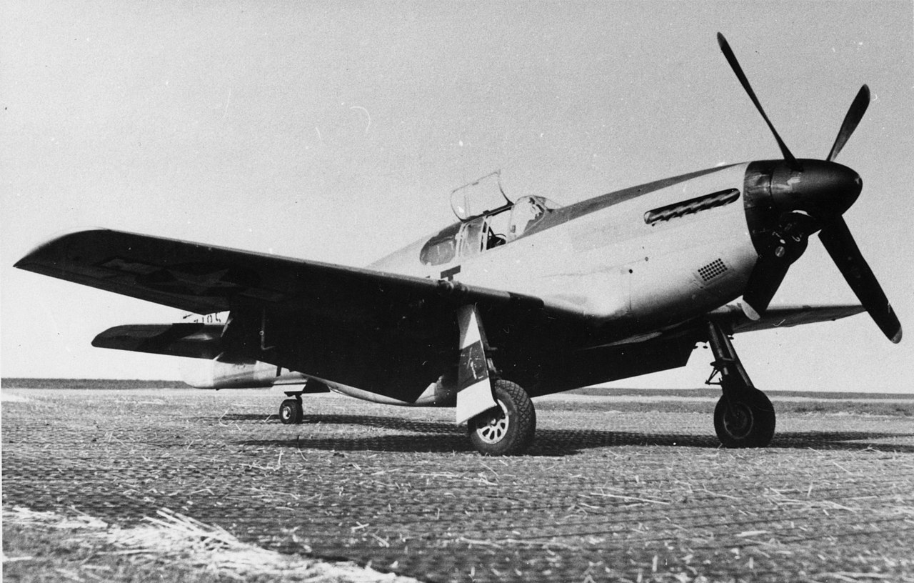 354th Fighter Group - P-51B Mustang at RAF Goxhill
 356th Fighter Group - P-47 Thunderbolt 42-74702 at RAF Goxhill
 496th Fighter Training Group - Spitfire Mk V at RAF Goxhill
 A Relic of Goxhill Airfield
 Equestrian Facility - Goxhill Airfield
 Goxhill Airfield Entrance
 Goxhill Airfield - Battle Headquarters
 Goxhill-092146
 Old Defence Post at Goxhill Airfield
 Old Dispersal Area for Goxhill Airfield
 Old Hangar at the former Goxhill Airfield.
 Old Military Building on the former Goxhill Airfield
 Old Military Building on the former Goxhill Airfield
 Old Taxi-strip at Goxhill
 Public Footpath across the old Goxhill Airfield
 Public Footpath to Goxhill
 RAF Goxhill - Flags
 Recreation of RAF Goxhill Control tower at the Military Aviation Museum
 The Hooded Horse, Goxhill
 The Public Footpath towards Chapel Field Road
 The Public Footpath to Goxhill
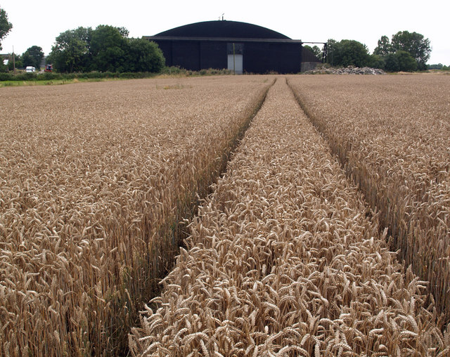 Tramlines in the Wheat
 Wartime Relic - College Road, Goxhill
 Wheat Crop on the former Goxhill Airfield