Fort York
From Warlike
Fort York is an early 19th-century military fortification in the Fort York neighbourhood of Toronto, Ontario, Canada. The fort housed members of the British and Canadian militaries and defended the entrance to Toronto Harbour. The fort features stone-lined earthwork walls and eight historical buildings within them, including two blockhouses. The fort forms a part of Fort York National Historic Site, a 16.6 ha (41-acre) site that includes the fort, Garrison Common, military cemeteries, and a visitor centre.
1793 Website,
Wikimedia, Wikidata
Canada, Canada, 
- Facebook channel@
- national historic event page@
- Ontario Heritage Act Register page@
- National Historic Sites of Canada page@
- National Historic Sites of Canada page@
- national historic event page@
- heritage conservation district page@
- Directory of Federal Heritage Designations page@
- Directory of Federal Heritage Designations page@
- Canadian Register of Historic Places page@
- Canadian Register of Historic Places page@
- Canadian Register of Historic Places page@
- Canadian Register of Historic Places page@
- FortWiki page@
- Starforts page@
- Tripadvisor page@
Location: 43.6389, -79.4036, KML, Cluster Map, Maps, ![]()
9 places
-

Battle of York ⓘ
war of 1812 battle -

Upper Canada Rebellion ⓘ
insurrection against the oligarchic government of the British colony of Upper Canada (present-day Ontario) in December 1837 -
Battle of Montgomery's Tavern ⓘ
1837 part of the Upper Canada Rebellion -

Fort Toronto ⓘ
historic French trading port in now Toronto, Ontario, Canada -
Magasin Royal ⓘ
colonial French trading post -

Fort Rouillé ⓘ
Abandoned French fort -

Fort York ⓘ
historic site in Toronto, Canada
-

Royal Canadian Military Institute ⓘ
private members' club in Toronto, Ontario -

48th Highlanders of Canada ⓘ
Canadian military unit
1793-01-01T00:00:00Z
1793-01-01T00:00:00Z
1793 Fort York
{"selectable":false,"showCurrentTime":false,"width":"100%","zoomMin":100000000000}
 Old Fort, Toronto looking east (HS85-10-20635)
 Fort York (I0014771)
 Fort York (I0014772)
 Pre-1801 Union Flag at Fort York, Toronto
 Old Fort York -- Fonds 200, Series 376, File 5, Item 15
 OldFORTyork
 Fort and Pier, Toronto
 Plan and front elevation of the lieutenant governor's house
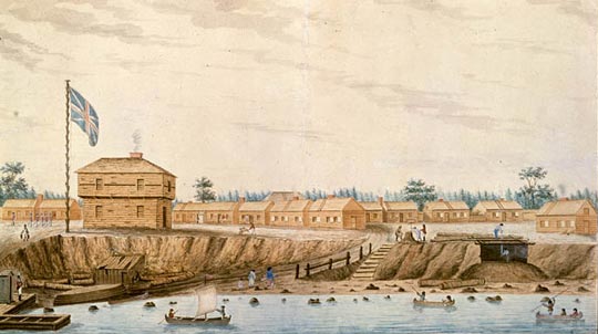 FortYork1804
 Pier and Fort, Toronto, 1839
| Type | Subtype | Date | Description | Notes | Source |
|---|---|---|---|---|---|
| event | armed conflict | 1813 | Battle of York | United States, battle, United Kingdom of Great Britain and Ireland | Wikidata |
| event | armed conflict | 1837 | Upper Canada Rebellion | rebellion | Wikidata |
| event | armed conflict | 1837 | Battle of Montgomery's Tavern | battle | Wikidata |
| link | channel | Facebook channel@ | Wikidata | ||
| link | page | national historic event page@ | Wikidata | ||
| link | page | Ontario Heritage Act Register page@ | Wikidata | ||
| link | page | National Historic Sites of Canada page@ | Wikidata | ||
| link | page | National Historic Sites of Canada page@ | Wikidata | ||
| link | page | national historic event page@ | Wikidata | ||
| link | page | heritage conservation district page@ | Wikidata | ||
| link | page | Directory of Federal Heritage Designations page@ | Wikidata | ||
| link | page | Directory of Federal Heritage Designations page@ | Wikidata | ||
| link | page | Canadian Register of Historic Places page@ | Wikidata | ||
| link | page | Canadian Register of Historic Places page@ | Wikidata | ||
| link | page | Canadian Register of Historic Places page@ | Wikidata | ||
| link | page | Canadian Register of Historic Places page@ | Wikidata | ||
| link | page | FortWiki page@ | Wikidata | ||
| link | page | Starforts page@ | Wikidata | ||
| link | page | Tripadvisor page@ | Wikidata | ||
| organisation | arms industry | Roshel | arms industry, automotive industry, business, manufacturer | Wikidata | |
| organisation | shipbuilding | 1886 | Polson Iron Works Limited | business, shipbuilding | Wikidata |
| site | fort | Fort Toronto | fort | Wikidata | |
| site | fort | 1720 | Magasin Royal | fort | Wikidata |
| site | fort | 1750 | Fort Rouillé | fort | Wikidata |
| site | fort | 1793 | Fort York | military museum, fort | Wikidata |
| site | museum | 1890 | Royal Canadian Military Institute | military museum | Wikidata |
| site | museum | 1959 | 48th Highlanders of Canada | military museum, militia | Wikidata |
| commons | image | Old Fort, Toronto looking east (HS85-10-20635) | Commons | ||
| commons | image | Fort York (I0014771) | Commons | ||
| commons | image | Fort York (I0014772) | Commons | ||
| commons | image | Pre-1801 Union Flag at Fort York, Toronto | Commons | ||
| commons | image | Old Fort York -- Fonds 200, Series 376, File 5, Item 15 | Commons | ||
| commons | image | OldFORTyork | Commons | ||
| commons | image | Fort and Pier, Toronto | Commons | ||
| commons | image | Plan and front elevation of the lieutenant governor's house | Commons | ||
| commons | image | FortYork1804 | Commons | ||
| commons | image | Pier and Fort, Toronto, 1839 | Commons | ||
.jpg)
.jpg)
.jpg)