Western sahara walls moroccan map-fr.svg
From Warlike

Size of this PNG preview of this SVG file: 772 × 600 pixels. Other resolutions: 309 × 240 pixels | 618 × 480 pixels | 989 × 768 pixels | 1,280 × 994 pixels | 2,560 × 1,989 pixels | 1,676 × 1,302 pixels.
Original file (SVG file, nominally 1,676 × 1,302 pixels, file size: 191 KB)
Summary
| Description |
[]
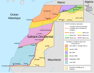
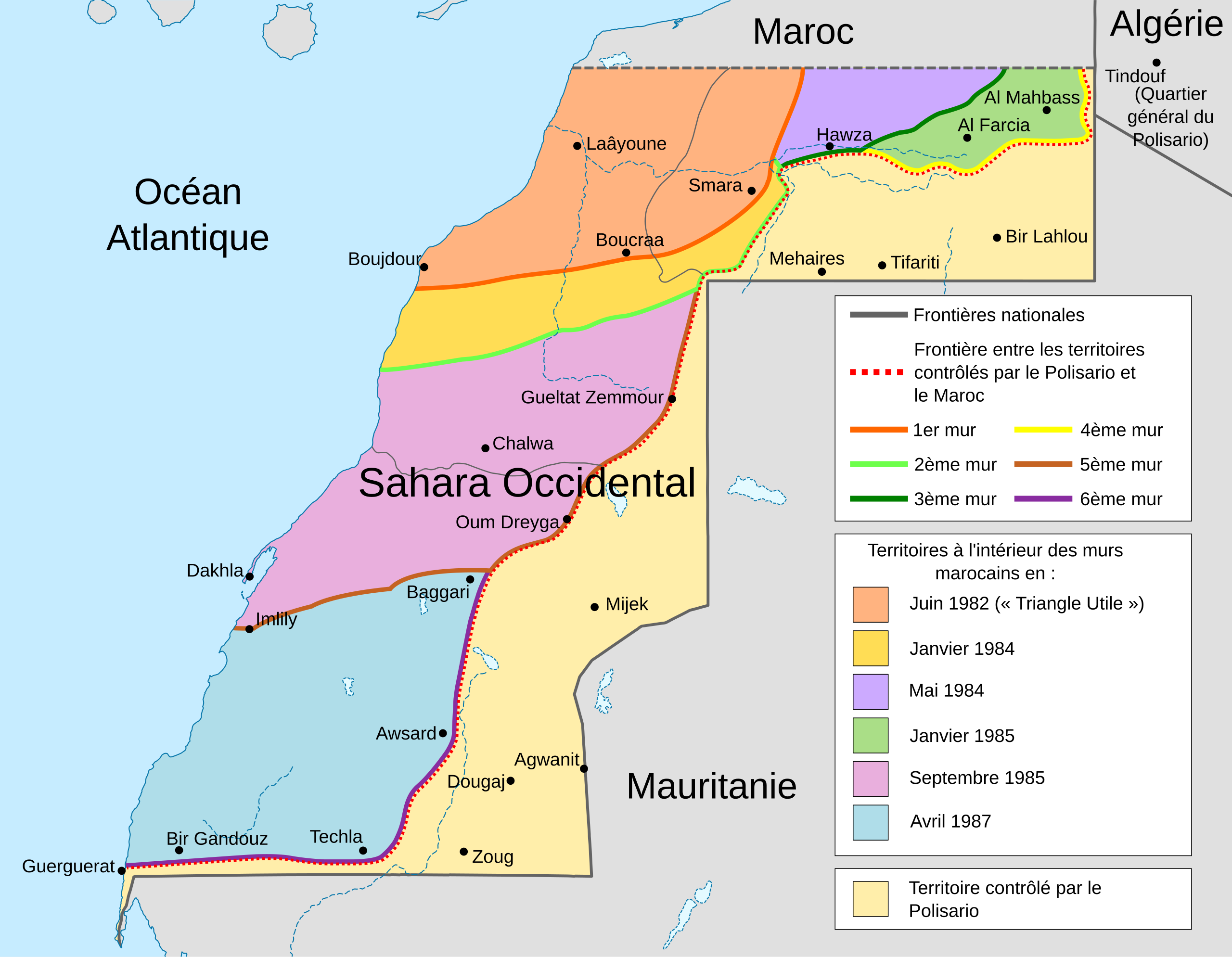
Deutsch: Karte des Marokkanischen Walls in der Westsahara. Er wurde in sechs Etappen in den 1980er Jahren errichtet, wie in der Karte dargestellt. Ebenfalls dargestellt ist das Polisario-Territorium und die Konfliktzone aus dem November 2020 (ermittelt anhand OSM). English: Map of the Moroccan Wall in Western Sahara - built over several stages, shows the six walls built, & when the territory was behind Moroccan wall. Also shows Polisario held territory who are based in Algeria (seen at top right). Euskara: Mendebaldeko Saharako harresien mapa العربية : خريطة الجدار الرملي المغربي في الصحراء الغربية |
||
| Date | (UTC) | ||
| Source | |||
| Author | |||
| Other versions |
[]
|


| This is a retouched picture, which means that it has been digitally altered from its original version. Modifications: french translation. The original can be viewed here: Western sahara walls moroccan map-en.svg:
|
| This SVG file contains embedded text that can be translated into your language, using any capable SVG editor, text editor or the SVG Translate tool. For more information see: About translating SVG files. |
Licensing
I, the copyright holder of this work, hereby publish it under the following licence:
This file is licensed under the Creative Commons Attribution-Share Alike 3.0 Unported licence.
- You are free:
- to share – to copy, distribute and transmit the work
- to remix – to adapt the work
- Under the following conditions:
- attribution – You must give appropriate credit, provide a link to the licence, and indicate if changes were made. You may do so in any reasonable manner, but not in any way that suggests the licensor endorses you or your use.
- share alike – If you remix, transform, or build upon the material, you must distribute your contributions under the same or compatible licence as the original.
Original upload log
This image is a derivative work of the following images:
- File:Western_sahara_walls_moroccan_map-en.svg licensed with Cc-by-sa-3.0
- 2011-08-17T09:01:54Z M0tty 1676x1302 (197399 Bytes) corr legend
- 2011-08-16T18:46:57Z M0tty 1676x1302 (194768 Bytes) {{Information |Description={{en|Map of the [[w:Moroccan Wall]] in [[w:Western Sahara]] - built over several stages, shows the six walls built, & when the territory was behind Moroccan wall. Also shows polisaro held territory
Uploaded with derivativeFX
File history
Click on a date/time to view the file as it appeared at that time.
| Date/Time | Thumbnail | Dimensions | User | Comment | |
|---|---|---|---|---|---|
| current | 17:03, 19 August 2011 | | 1,676 × 1,302 (191 KB) | wikimediacommons>M0tty | Small correction |
File usage
There are no pages that use this file.