Vöcklabruck - oberer Stadtturm (1).JPG
From Warlike
File:Vöcklabruck - oberer Stadtturm (1).JPG

Size of this preview: 399 × 599 pixels. Other resolutions: 160 × 240 pixels | 320 × 480 pixels | 512 × 768 pixels | 682 × 1,024 pixels | 1,365 × 2,048 pixels | 3,181 × 4,772 pixels.
Original file (3,181 × 4,772 pixels, file size: 9.75 MB, MIME type: image/jpeg)
Summary
| Description |
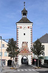
Deutsch: Südsüdwestansicht des oberen Stadtturmes der oberösterreichischen Stadt Vöcklabruck.
Der obere Stadtturm entstand wie auch der untere Stadtturm zu Beginn des 14. Jahrhunderts. Der Turm hat eine gemauerte Höhe von fast 21 Meter und südwestseitig eine 1503 entstandenen Fassadenmalerei. Dessen Hauptmotiv zeigt die schon im ältesten bekannten Vöcklabrucker Stadtsiegel dargestellte Szene der beiden in die Stadt reitenden Ritter. Im dreieckigen Feld unterhalb sind die acht Wappen der österreichischen Erbländer dargestellt, sowie der von zwei Löwen gehaltene doppelköpfige Reichsadler und darüber das Stammwappen der Habsburger. |
| Date | |
| Source | Own work |
| Author | C.Stadler/Bwag |
| Permission (Reusing this file) |
Deutsch: Hallo, du darfst meine Fotos kostenlos nutzen, aber nenne mich bitte als Fotograf, beispielsweise „Foto: C.Stadler/Bwag“ oder © C.Stadler/Bwag; CC-BY-SA-4.0. Auf mehr Angaben bestehe ich nicht - im Gegensatz zu manch anderen, die die Vorgaben der unten angeführten Lizenzierung auf Punkt und Beistrich einfordern. English: Feel free to use my photos, but please mention me as the author like © C.Stadler/Bwag or © C.Stadler/Bwag; CC-BY-SA-4.0 (that's good enough) and if you want send me a message: bwag@gmx.net. |
| Other versions |
|
.JPG)
.JPG)
| Object location | | View this and other nearby images on: OpenStreetMap |
|---|
.JPG¶ms=048.007200_N_0013.653390_E_globe:Earth_class:object_type:object__&language=en-gb)
| Camera location | | View this and other nearby images on: OpenStreetMap |
|---|
.JPG¶ms=048.006880_N_0013.653170_E_globe:Earth_type:camera_heading:25.00&language=en-gb)
Licensing
I, the copyright holder of this work, hereby publish it under the following licence:
This file is licensed under the Creative Commons Attribution-Share Alike 4.0 International licence.
- You are free:
- to share – to copy, distribute and transmit the work
- to remix – to adapt the work
- Under the following conditions:
- attribution – You must give appropriate credit, provide a link to the licence, and indicate if changes were made. You may do so in any reasonable manner, but not in any way that suggests the licensor endorses you or your use.
- share alike – If you remix, transform, or build upon the material, you must distribute your contributions under the same or compatible licence as the original.
File history
Click on a date/time to view the file as it appeared at that time.
| Date/Time | Thumbnail | Dimensions | User | Comment | |
|---|---|---|---|---|---|
| current | 19:48, 29 October 2019 | | 3,181 × 4,772 (9.75 MB) | wikimediacommons>Bwag | {{Information |Description= {{de|1= Südsüdwestansicht des oberen Stadtturmes der oberösterreichischen Stadt Vöcklabruck.<br/>Der obere Stadtturm entstand wie auch der untere Stadtturm in seiner heutigen Form zu Beginn des 14. Jahrhunderts. Das Hauptmotiv der 1503 entstandenen Fassadenmalerei des oberen, westlichen Turmes zeigt die schon im ältesten bekannten Vöcklabrucker Stadtsiegel dargestellte Szene der beiden in die Stadt reitenden Ritter. Im dreieckigen Feld unterhalb... |
File usage
The following page uses this file:
.JPG)