Svinesund - KMB - 16000300022911.jpg
From Warlike

No higher resolution available.
Svinesund_-_KMB_-_16000300022911.jpg (730 × 487 pixels, file size: 61 KB, MIME type: image/jpeg)
| Svinesund
( |
|||||||||||||||||||||||||||
|---|---|---|---|---|---|---|---|---|---|---|---|---|---|---|---|---|---|---|---|---|---|---|---|---|---|---|---|
| Photographer |
|
||||||||||||||||||||||||||
| Title |
Svinesund |
||||||||||||||||||||||||||
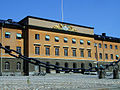
| Original caption |
Notera Av dokumentationsskäl har originalbeskrivningen från Riksantikvarieämbetet behållits. Tillrättalägganden och alternativa beskrivningar bör införas separat från nedanstående information. Svinesundsbron, med svenska sidan till höger på bilden. Sedan 1600-talet gränsort med befästningsanläggningar från 1700-talet. Bl.a. Hogdal 155:1.Felaktigheter kan även anmälas till denna sida. Motiv: Svinesund |
||||||||||||||||||||||||||
| Description |
Svinesundsbron, med svenska sidan till höger på bilden. Sedan 1600-talet gränsort med befästningsanläggningar från 1700-talet. Bl.a. Hogdal 155:1.
|
||||||||||||||||||||||||||
| Depicted place | Sweden, Strömstad Municipality, Q10525067 | ||||||||||||||||||||||||||
| Date | 26 March 1990 | ||||||||||||||||||||||||||
| Collection |
|
||||||||||||||||||||||||||
| Accession number | |||||||||||||||||||||||||||
| Source |
Jan Norrman / Kulturmiljöbild, Riksantikvarieämbetet
|
||||||||||||||||||||||||||
| Permission (Reusing this file) |
This file is licensed under the Creative Commons Attribution 2.5 Generic licence. Attribution: Jan Norrman / Riksantikvarieämbetet
|
||||||||||||||||||||||||||

| Object location | | View this and other nearby images on: OpenStreetMap |
|---|
File history
Click on a date/time to view the file as it appeared at that time.
| Date/Time | Thumbnail | Dimensions | User | Comment | |
|---|---|---|---|---|---|
| current | 19:28, 18 November 2020 | | 730 × 487 (61 KB) | wikimediacommons>Nasko | Cropped 5 % horizontally, 5 % vertically using CropTool with lossless mode. |
File usage
There are no pages that use this file.