Sud Italia nel 1112.jpg
From Warlike
Size of this preview: 529 × 600 pixels. Other resolutions: 212 × 240 pixels | 423 × 480 pixels | 712 × 807 pixels.
Original file (712 × 807 pixels, file size: 94 KB, MIME type: image/jpeg)
Summary
| Description |
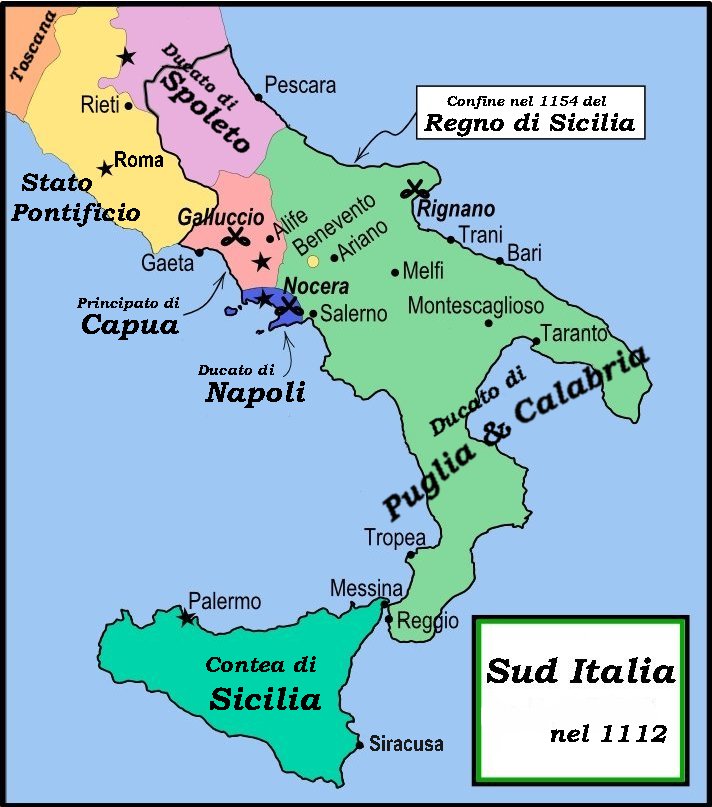
English: This is a political map of southern Italy in 1112 AD/CE, the date when Roger II of Sicily reached his age of majority, also showing the border of the Kingdom of Sicily in 1154, on his death.
"The rarity of surviving records makes it impossible to draw a map of comital [counts'] responsibiities in southern Italy at the beginning of the twelth century." Matthew, p. 23. As noted by Matthew, the political situation in southern Italy is much more complex than this map shows. There were numerous counts and semi-independent cities throughout the region. Moreover, the near-constant rebellions and conquests continually re-arranged the map. |
| Date | |
| Source | File:Southern Italy 1112.svg MapMaster |
| Author | MapMaster |
| Other versions |
[]
|


References
- Bjorklund, Oddvar; Holmboe, Haakon; Rohr, Anders (1970) Historical Atlas of the World, Barnes & Noble, NY, SBN: 389-00253-4.
- Houben, Hubert (translated by Graham A. Loud and Diane Milburn), (2002) Roger II of Sicily: Ruler between East and West, Cambridge University Press.
- Konstam, Angus (2000) Atlas of Medieval Europe, Checkmark Books, New York.
- Matthew, Donald (1992) Cambridge Medieval Textbooks, ed. The Norman Kingdom of Sicily
Licensing
I, the copyright holder of this work, hereby publish it under the following licences:

|
Permission is granted to copy, distribute and/or modify this document under the terms of the GNU Free Documentation Licence, Version 1.2 or any later version published by the Free Software Foundation; with no Invariant Sections, no Front-Cover Texts, and no Back-Cover Texts. A copy of the licence is included in the section entitled GNU Free Documentation Licence. |
This file is licensed under the Creative Commons Attribution-Share Alike 4.0 International, 3.0 Unported, 2.5 Generic, 2.0 Generic and 1.0 Generic license.
- You are free:
- to share – to copy, distribute and transmit the work
- to remix – to adapt the work
- Under the following conditions:
- attribution – You must give appropriate credit, provide a link to the licence, and indicate if changes were made. You may do so in any reasonable manner, but not in any way that suggests the licensor endorses you or your use.
- share alike – If you remix, transform, or build upon the material, you must distribute your contributions under the same or compatible licence as the original.
You may select the licence of your choice.
File history
Click on a date/time to view the file as it appeared at that time.
| Date/Time | Thumbnail | Dimensions | User | Comment | |
|---|---|---|---|---|---|
| current | 18:59, 1 March 2008 | | 712 × 807 (94 KB) | wikimediacommons>Franco aq | {{Information |Description= |Source=Wikimedia Commons |Date=01 03 2008 |Author=User:MapMaster |other_versions=Image:Southern Italy 1112.svg }} |
File usage
There are no pages that use this file.