Sketch of the Battle of Kernstown, Sunday, March 23d 1862 LOC 2005625007.jpg
From Warlike

Size of this preview: 443 × 599 pixels. Other resolutions: 177 × 240 pixels | 355 × 480 pixels | 568 × 768 pixels | 757 × 1,024 pixels | 1,514 × 2,048 pixels | 2,633 × 3,562 pixels.
Original file (2,633 × 3,562 pixels, file size: 1.89 MB, MIME type: image/jpeg)
Summary
| Description |
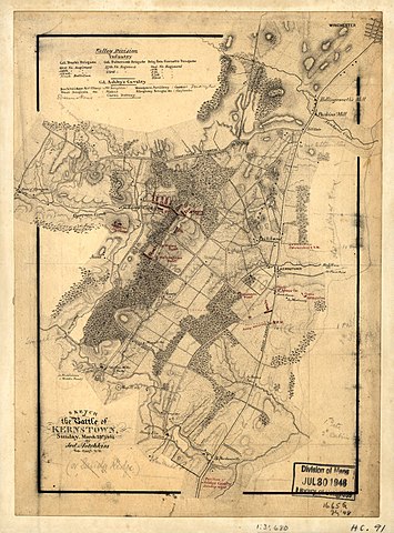
English: Shows Confederate troop positions and names of some residents. Relief shown by hachures. Pen-and-ink with pencil corrections and additions, mounted on cloth. LC Civil War maps (2nd ed.), H91 Includes listings of brigades and regiments of the Valley Division and Colonel Ashby's Cavalry. Stamped on verso: 1299. In pencil on verso: 2. Available also through the Library of Congress web site as raster image. |
||
| Title | Sketch of the Battle of Kernstown, Sunday, March 23d 1862 | ||
| Shelf ID | G3884.W6:2K4S5 1862 .H62 | ||
| Date | |||
| Source | https://www.loc.gov/item/2005625007/ | ||
| Author | Hotchkiss, Jedediah | ||
| Permission (Reusing this file) |
|
||
| Other versions |
|
||
| Location | United States · Virginia · Winchester | ||
| Part of | Civil War Maps · Hotchkiss Map Collection · Military Battles And Campaigns · Catalog · American Memory · Geography And Map Division | ||
| Subject | Maps, Manuscript · Winchester · Virginia · Kernstown, 1St Battle Of, Winchester, Va · United States · Maps · Kernstown, 1St Battle Of, Winchester, Va. · Landowners |


Licensing
|
This is a faithful photographic reproduction of a two-dimensional, public domain work of art. The work of art itself is in the public domain for the following reason:
The official position taken by the Wikimedia Foundation is that "faithful reproductions of two-dimensional public domain works of art are public domain".
This photographic reproduction is therefore also considered to be in the public domain in the United States. In other jurisdictions, re-use of this content may be restricted; see Reuse of PD-Art photographs for details. | ||||
File history
Click on a date/time to view the file as it appeared at that time.
| Date/Time | Thumbnail | Dimensions | User | Comment | |
|---|---|---|---|---|---|
| current | 17:10, 15 May 2018 | | 2,633 × 3,562 (1.89 MB) | wikimediacommons>Fæ | LOC Maps https://www.loc.gov/item/2005625007/ #9059 |
File usage
There are no pages that use this file.