Sauerburg nahe Kaub im Weltkulturerbe oberes Mittelrheintal.jpg
From Warlike

Size of this preview: 800 × 533 pixels. Other resolutions: 320 × 213 pixels | 640 × 427 pixels | 1,024 × 683 pixels | 1,280 × 853 pixels | 2,560 × 1,707 pixels | 6,048 × 4,032 pixels.
Original file (6,048 × 4,032 pixels, file size: 26.79 MB, MIME type: image/jpeg)
Summary
| Description |
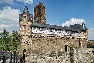
Deutsch: Die Kernburg ist von einem trapezförmigem Bering umschlossen. In seine nördliche Angriffsseite ist der 32 m hohe, beherrschende, quadratische Hauptturm eingestellt. Der heute geborstene, 2004 sanierte Turm hatte über einem Verlies sechs Stockwerke bis zur Wehrplatte, weist an der SW-Seite in Wehrganghöhe einen Eingang auf und ist innen mit Kaminen ausgestattet. An der Nordostseite der Kernburg stand an der Stelle des heutigen Wohnbaus der ehemalige, dreistöckige Palas
English: The core castle is enclosed by a trapezoidal bering. In its northern attack side is set the 32 m high, dominant, square main tower. The tower, which has been demolished today and renovated in 2004, had six floors above a dungeon up to the weir slab, has an entrance on the SW side at battlement height and is equipped with chimneys inside. On the northeast side of the core castle stood on the site of today's residential building the former, three-storey Palas |
| Date | |
| Source | Own work |
| Author | Xjvolker |
| Camera location | | View this and other nearby images on: OpenStreetMap |
|---|
Licensing
I, the copyright holder of this work, hereby publish it under the following licence:
This file is licensed under the Creative Commons Attribution-Share Alike 4.0 International licence.
- You are free:
- to share – to copy, distribute and transmit the work
- to remix – to adapt the work
- Under the following conditions:
- attribution – You must give appropriate credit, provide a link to the licence, and indicate if changes were made. You may do so in any reasonable manner, but not in any way that suggests the licensor endorses you or your use.
- share alike – If you remix, transform, or build upon the material, you must distribute your contributions under the same or compatible licence as the original.

|
This image was uploaded as part of Wiki Loves Monuments 2022.
|
File history
Click on a date/time to view the file as it appeared at that time.
| Date/Time | Thumbnail | Dimensions | User | Comment | |
|---|---|---|---|---|---|
| current | 22:07, 14 September 2022 | | 6,048 × 4,032 (26.79 MB) | wikimediacommons>Xjvolker | Uploaded own work with UploadWizard |
File usage
There are no pages that use this file.