San Marino Guaita.jpg
From Warlike

Size of this preview: 800 × 540 pixels. Other resolutions: 320 × 216 pixels | 640 × 432 pixels | 1,024 × 691 pixels | 1,280 × 864 pixels | 2,560 × 1,728 pixels | 3,688 × 2,490 pixels.
Original file (3,688 × 2,490 pixels, file size: 9.85 MB, MIME type: image/jpeg)
Summary
| Description |
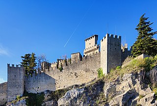
English: Guaita tower at San Marino. |
| Date | |
| Source | Own work |
| Author | Terragio67 |
| Object location | | View this and other nearby images on: OpenStreetMap |
|---|
| Camera location | | View this and other nearby images on: OpenStreetMap |
|---|
Licensing
I, the copyright holder of this work, hereby publish it under the following licence:
This file is licensed under the Creative Commons Attribution-Share Alike 4.0 International licence.
- You are free:
- to share – to copy, distribute and transmit the work
- to remix – to adapt the work
- Under the following conditions:
- attribution – You must give appropriate credit, provide a link to the licence, and indicate if changes were made. You may do so in any reasonable manner, but not in any way that suggests the licensor endorses you or your use.
- share alike – If you remix, transform, or build upon the material, you must distribute your contributions under the same or compatible licence as the original.
This image has been assessed using the Quality image guidelines and is considered a Quality image.
|
File history
Click on a date/time to view the file as it appeared at that time.
| Date/Time | Thumbnail | Dimensions | User | Comment | |
|---|---|---|---|---|---|
| current | 22:24, 9 May 2022 | | 3,688 × 2,490 (9.85 MB) | wikimediacommons>Terragio67 | Uploaded while editing "Commons:Quality images candidates/candidate list" on commons.wikimedia.org |
File usage
There are no pages that use this file.