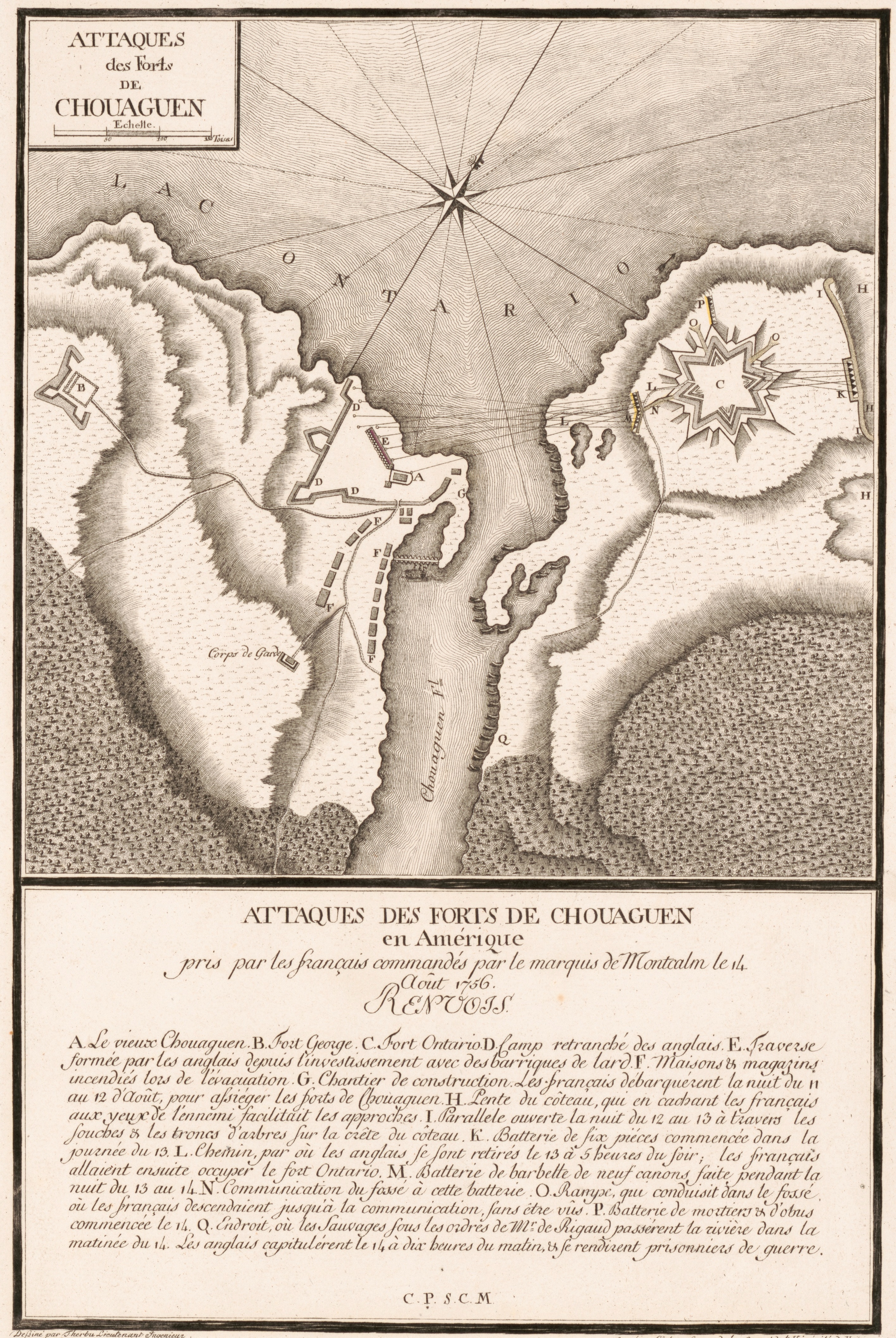
Plan des forts pris par Montcalm en août 1756. Bataille d'Oswego.jpg
From Warlike
Size of this preview: 401 × 599 pixels. Other resolutions: 161 × 240 pixels | 321 × 480 pixels | 514 × 768 pixels | 686 × 1,024 pixels | 1,371 × 2,048 pixels | 2,831 × 4,227 pixels.
Original file (2,831 × 4,227 pixels, file size: 5.37 MB, MIME type: image/jpeg)
Summary
| Description |
Français : Carte publiée sous le titre « Attaques des forts de Chouaguen en Amérique : pris par les français commandé par le marquis de Montcalm le 14 août 1756 ». Campagne de 1756 lors de la guerre de la Conquête (Guerre de Sept Ans en Europe).
English: Engraved map of the British fortifications at the mouth of the Oswego River (now in city of Oswego, N.Y.) as depicted by the French. Shows military actions taken in the capture of Fort Oswego (August 1756). Relief shown by shading and rock drawings. This map originally appeared in the atlas "Les plans de la guerre de sept ans" issued in parts between 1789 and 1791 in Mainz (Germany). Includes index of battle sites and actions titled "Renvois". |
| Date | - 1757 ? |
| Source | Librairie du Congrès |
| Author | Therbu, L., Cöntgen Georg Joseph. |
Licensing
|
This is a faithful photographic reproduction of a two-dimensional, public domain work of art. The work of art itself is in the public domain for the following reason:
The official position taken by the Wikimedia Foundation is that "faithful reproductions of two-dimensional public domain works of art are public domain".
This photographic reproduction is therefore also considered to be in the public domain in the United States. In other jurisdictions, re-use of this content may be restricted; see Reuse of PD-Art photographs for details. | ||||
File history
Click on a date/time to view the file as it appeared at that time.
| Date/Time | Thumbnail | Dimensions | User | Comment | |
|---|---|---|---|---|---|
| current | 11:33, 24 February 2019 | | 2,831 × 4,227 (5.37 MB) | wikimediacommons>AYE R | User created page with UploadWizard |
File usage
There are no pages that use this file.