Plan der franzoesischen Festung Valenciennes.jpg
From Warlike

Size of this preview: 800 × 588 pixels. Other resolutions: 320 × 235 pixels | 640 × 471 pixels | 1,024 × 753 pixels | 1,280 × 941 pixels | 2,560 × 1,882 pixels | 9,041 × 6,647 pixels.
Original file (9,041 × 6,647 pixels, file size: 15.58 MB, MIME type: image/jpeg)
Summary
| Description |
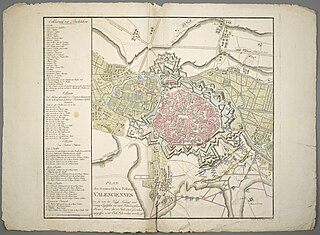
Deutsch: 1 Kt. : kolor. (55 x 48 cm) ; Koordinaten E 3°30'04"-E 3°33'14"/N 50°22'33"-N 50°20'31" ; Maßstab in graph. Form (Kl[after]). - Titel und Maßstab unten links. - Mit Truppenstellungen. - Mit Legende links. - Ohne Kt.-Netz. - W oben. - Relief: Schraffen |
| Date | after 1793 |
| Source | Leibniz-Institut für Länderkunde e.V., Leipzig |
| Author | Walch, Johannes (Herausgeber/-in) |
Altkarte ; Militärkartographie
Licensing
| This file is made available under the Creative Commons CC0 1.0 Universal Public Domain Dedication. | |
| The person who associated a work with this deed has dedicated the work to the public domain by waiving all of their rights to the work worldwide under copyright law, including all related and neighbouring rights, to the extent allowed by law. You can copy, modify, distribute and perform the work, even for commercial purposes, all without asking permission.
|
File history
Click on a date/time to view the file as it appeared at that time.
| Date/Time | Thumbnail | Dimensions | User | Comment | |
|---|---|---|---|---|---|
| current | 14:21, 22 January 2019 | | 9,041 × 6,647 (15.58 MB) | wikimediacommons>Higgenhorscht | User created page with UploadWizard |
File usage
There are no pages that use this file.