Plan de la bataille de Vire-Culs.jpg
From Warlike
File:Plan de la bataille de Vire-Culs.jpg

Size of this preview: 800 × 476 pixels. Other resolutions: 320 × 190 pixels | 640 × 381 pixels | 1,024 × 610 pixels | 1,280 × 762 pixels | 2,982 × 1,775 pixels.
Original file (2,982 × 1,775 pixels, file size: 797 KB, MIME type: image/jpeg)
Summary
| Description |
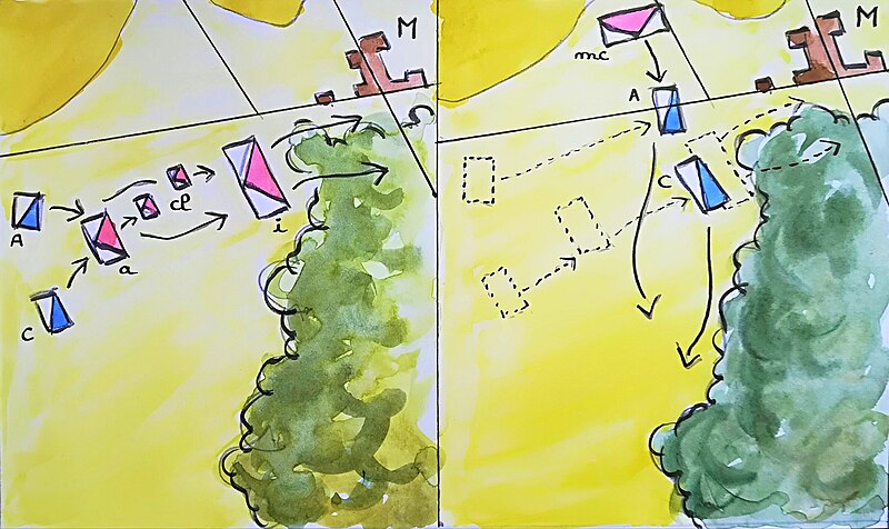
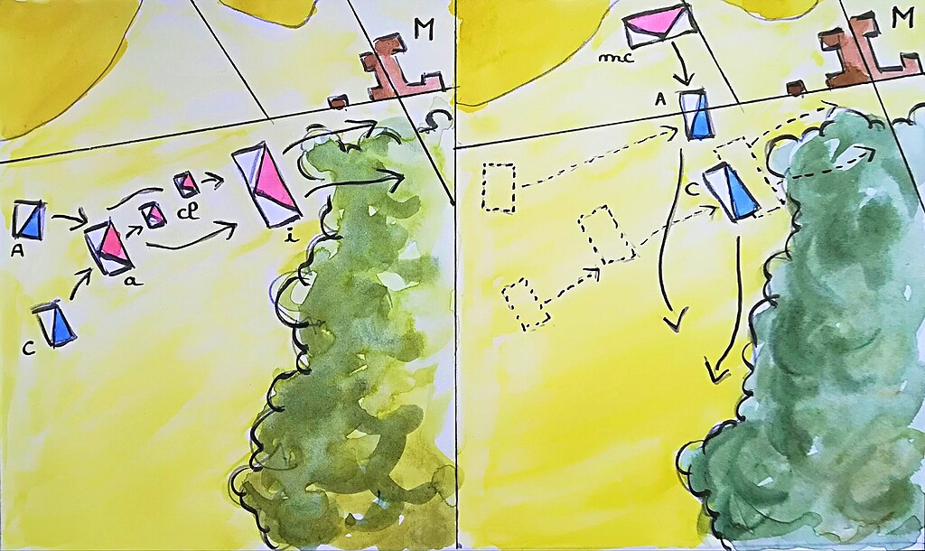
Français : Plan de la bataille de Vire-Culs, le 10 décembre 1587 : les arquebusiers à cheval (A) et les cuirassiers protestants (C) chargent les arquebusiers à cheval (a) et les chevau-légers catholiques (cl), qui sont mis en déroute et rejetés sur l'infanterie de l'avant-garde (i), laquelle se joint à la débandade générale. Les cavaliers protestants sont alors contre-attaqués et dispersés par les cuirassiers de Mandelot (mc), arrivés à leur tour sur le champ de bataille. En haut à droite, le hameau de Métrieux (M).
Schéma établi d'après un plan publié dans Gisèle Bonnay, « La bataille de Vire-Culs », Dan l'tan, Visages de notre Pilat, 1982, p. 19. |
| Date | |
| Source | Own work |
| Author | Kozam |
| Camera location | | View this and other nearby images on: OpenStreetMap |
|---|
Licensing
I, the copyright holder of this work, hereby publish it under the following licence:
This file is licensed under the Creative Commons Attribution-Share Alike 4.0 International licence.
- You are free:
- to share – to copy, distribute and transmit the work
- to remix – to adapt the work
- Under the following conditions:
- attribution – You must give appropriate credit, provide a link to the licence, and indicate if changes were made. You may do so in any reasonable manner, but not in any way that suggests the licensor endorses you or your use.
- share alike – If you remix, transform, or build upon the material, you must distribute your contributions under the same or compatible licence as the original.
File history
Click on a date/time to view the file as it appeared at that time.
| Date/Time | Thumbnail | Dimensions | User | Comment | |
|---|---|---|---|---|---|
| current | 19:49, 21 June 2019 | | 2,982 × 1,775 (797 KB) | wikimediacommons>Kozam | Meilleure version |
File usage
The following page uses this file: