Perchtoldsdorf (3).JPG
From Warlike
File:Perchtoldsdorf (3).JPG

Size of this preview: 800 × 578 pixels. Other resolutions: 320 × 231 pixels | 640 × 463 pixels | 1,024 × 740 pixels | 1,280 × 925 pixels | 2,560 × 1,850 pixels | 3,898 × 2,817 pixels.
Original file (3,898 × 2,817 pixels, file size: 10.2 MB, MIME type: image/jpeg)
Summary
| Description |
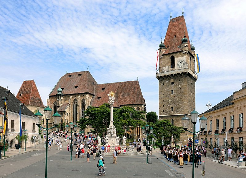
Deutsch: Der Marktplatz der niederösterreichischen Marktgemeinde Perchtoldsdorf. Links das sogenannte Regenharthaus, ein Bürgerhaus mit einer Kernsubstanz aus dem 15. Jahrhundert und hinter diesem die Martinskapelle bzw. der ehemalige Karner mit dem steilem Keildach. In der Bildmitte die Pfarrkirche hl. Augustinus und vor dieser die barocke Dreifaltigkeitssäule. Rechts der Wehrturm, ein von 1450 bis 1521 erbauter fünfgeschoßiger Turm, und ganz rechts das Gemeindeamt, ein ehemaliger späthistoristischer Meierhof aus dem Jahr 1838. Die Aufnahme wurde am Perchtoldsdorfer Fronleichnamstag gemacht, der gegenüber dem „regulären“ Fronleichnamstag um 10 Tage später gefeiert wird. |
| Date | |
| Source | Own work |
| Author | C.Stadler/Bwag |
| Permission (Reusing this file) |
Deutsch: Hallo, du darfst meine Fotos kostenlos nutzen, aber nenne mich bitte als Fotograf, beispielsweise „Foto: C.Stadler/Bwag“ oder © C.Stadler/Bwag; CC-BY-SA-4.0. Auf mehr Angaben bestehe ich nicht - im Gegensatz zu manch anderen, die die Vorgaben der unten angeführten Lizenzierung auf Punkt und Beistrich einfordern. English: Feel free to use my photos, but please mention me as the author like © C.Stadler/Bwag or © C.Stadler/Bwag; CC-BY-SA-4.0 (that's good enough) and if you want send me a message: bwag@gmx.net. |
| Other versions |
|
.JPG)

.JPG)
| Camera location | | View this and other nearby images on: OpenStreetMap |
|---|
.JPG¶ms=048.118930_N_0016.265310_E_globe:Earth_type:camera_heading:335.00&language=en-gb)
Licensing
I, the copyright holder of this work, hereby publish it under the following licence:
This file is licensed under the Creative Commons Attribution-Share Alike 4.0 International licence.
- You are free:
- to share – to copy, distribute and transmit the work
- to remix – to adapt the work
- Under the following conditions:
- attribution – You must give appropriate credit, provide a link to the licence, and indicate if changes were made. You may do so in any reasonable manner, but not in any way that suggests the licensor endorses you or your use.
- share alike – If you remix, transform, or build upon the material, you must distribute your contributions under the same or compatible licence as the original.
File history
Click on a date/time to view the file as it appeared at that time.
| Date/Time | Thumbnail | Dimensions | User | Comment | |
|---|---|---|---|---|---|
| current | 17:39, 7 July 2017 | | 3,898 × 2,817 (10.2 MB) | wikimediacommons>Bwag | b |
File usage
The following page uses this file:
.JPG)