Panoramic of Juan Griego 45.jpg
From Warlike
Original file (4,009 × 2,463 pixels, file size: 12.1 MB, MIME type: image/jpeg)
Summary
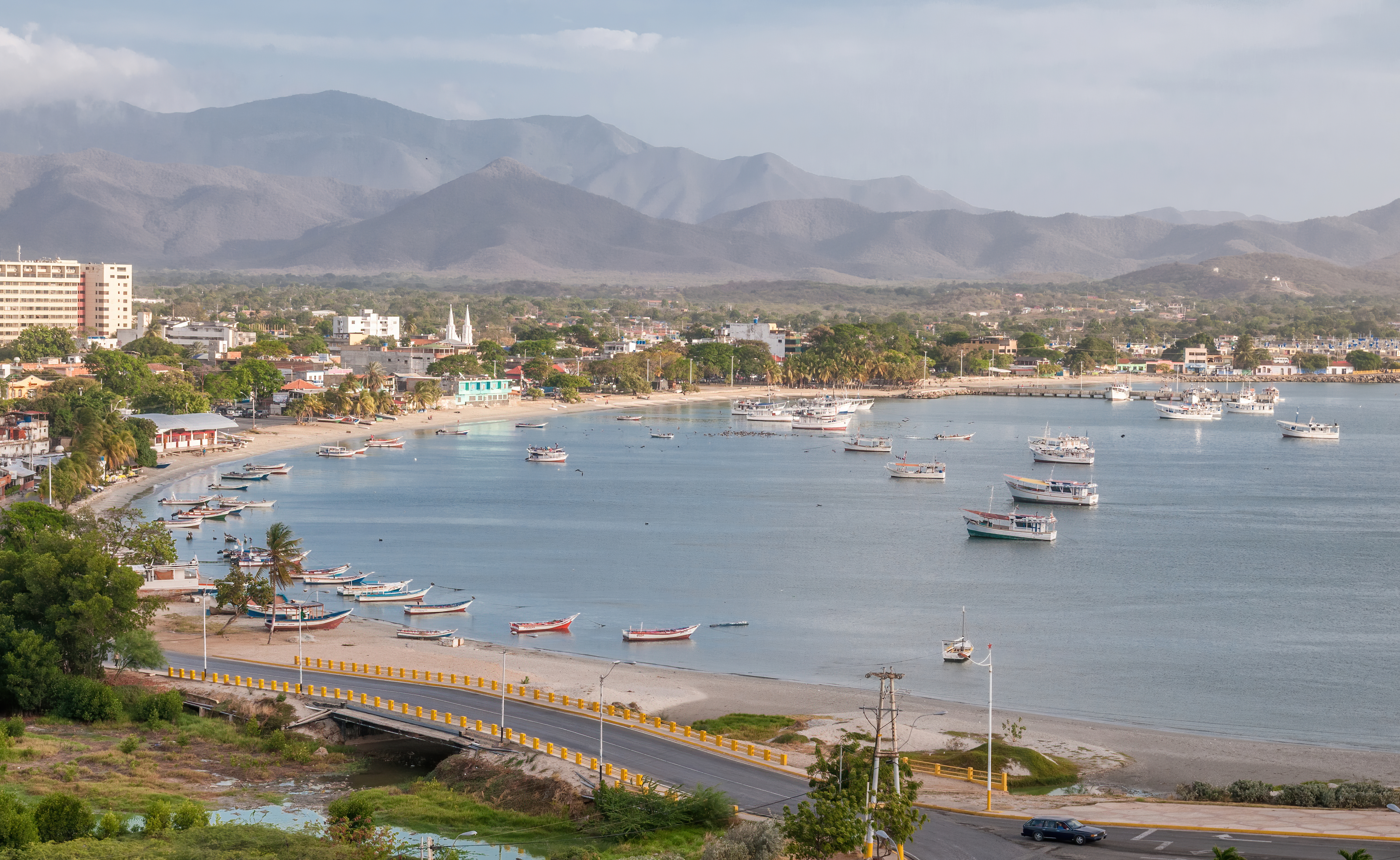
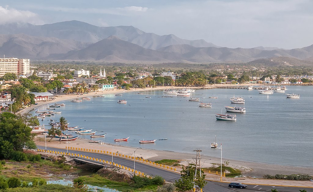
{{Information |description={{Multilingual description|en=en=Panoramic view of Juan Griego bay from Fort La Galera. Juan Griego is a city on the northern side of Isla Margarita, and is the most northern port in Venezuela.|es=Vista panorámica de la bahía de Juan Griego desde el Fortín de La Galera. Juan Griego es una ciudad al lado norte de la Isla Margarita y es el puerto más septentrional de Venezuela.|fr=Vue panoramique de w:Juan Griego baie de Fort La Galera. Juan Griego est une ville du nord d'Isla Margarita.|pt=Vista panorâmica da baía [[:w:Juan Griego]Juan Griego]] de Fort La Galera. Juan Griego é uma cidade da Venezuela localizada no distrito de Isla Margarita.|ru=Панорамный вид бухты Juan Griego из Форт-Ла-Галера. Хуан Гриего — город на северной стороне острова Маргарита и самый северный порт Венесуэлы.|zh=[:w: Juan Griego| Juan Griego] 从La Galera堡出发的海湾全景. 胡安·格里戈(Juan Griego)是位于玛格丽塔岛北侧的一座城市,也是委内瑞拉最北端的港口.|de=Panoramablick auf Juan Griego Bucht von Fort La Galera. Juan Griego ist eine Stadt auf der nördlichen Seite von Isla Margarita und ist der nördlichste Hafen in Venezuela.|es=en=Vista panorámica de la bahía de Fort La Galera. Juan Griego es una ciudad en el lado norte de Isla Margarita, y es el puerto más septentrional de Venezuela. prehensies=Vista panorámica de la bahía de w:es:Juan Griego sometidaJuan Griego desde el Fortín de La Galera. Juan Griego es una ciudad al lado norte de la Isla Margarita y es el puerto más norte de Venezuela. habitfr=Vue panoramique de w:Juan Griego baie de Fort La Galera. Juan Griego est une ville du nord d'Isla Margarita. sometidapt=Vista panorâmica da baía [[:w:Juan Griego]Juan Griego]]] de Fort La Galera. Juan Griego é uma cidade da Venezuela localizada no distrito de Isla Margarita. ←ru=анорамный вид бухты w:Juan Griego ←Juan Griego из Форт-Ла-Галера. [Leer más] Bucht von Fort La Galera. Juan Griego ist eine Stadt auf der nördlichen Seite von Isla Margarita und ist der nördlichste Hafen en Venezuela.|fr=fr=Vue panoramique de w:Juan Griego baie de Fort La Galera. Juan Griego est une ville du nord d'Isla Margarita. Desde el Fortín de La Galera. Juan Griego es una ciudad al lado norte de la Isla Margarita y es el puerto más septentrional de Venezuela. Juan Griego est une ville du nord d'Isla Margarita. Juan Griego é uma cidade da Venezuela localizada no distrito de Isla Margarita. [:w:Juan Griego]] иш орт-а-алера. Il n'y a pas d'autre chose à dire. Bucht von Fort La Galera. Juan Griego ist eine Stadt auf der nördlichen Seite von Isla Margarita und ist der nördlichste Hafen au Venezuela.|pt=en=Panoramic view of [[:w:Juan Griego]Juan Griego]] bay from Fort La Galera. Juan Griego é uma cidade da Venezuela localizada no distrito de Isla Margarita. == Localidades na vizinhança ==O diagrama seguinte representa as localidades num raio de 16 km ao redor de Pueblo. Juan Griego es una ciudad al lado norte de la Isla Margarita y es el puerto más septentrional de Venezuela. Juan Griego est une ville du nord d'Isla Margarita. Juan Griego é uma cidade da Venezuela localizada no distrito de Isla Margarita. w:Juan Griego из عорт-) бухтра. O que é isso? Bucht von Fort La Galera. Juan Griego ist eine Stadt auf der nördlichen Seite von Isla Margarita und ist der nördlichste Hafen, na Venezuela.|ru=en=Панорамический вид бухты Juan Griego из Форт-Ла-Галера. Хуан Гриего — город на северной стороне острова Маргарита и самый северный порт Венесуэлы. ↑ Vista panorámica de la bahía de Juan Griego desde el Fortín de La Galera. Juan Griego es una ciudad al lado norte de la Isla Margarita y es el puerto más septentrional de Venezuela. Juan Griego est une ville du nord d'Isla Margarita. |pt=Vista panorâmica da baía w:Juan Griego de Fort La Galera. Juan Griego é uma cidade da Venezuela localizada no distrito de Isla Margarita. [:w:Juan Griego [Juan Griego]] Форт-Ла-Гера. Хуан Григо — еверной ] ] ] ] ] ] ] ] ] ] ] ] ] ] ] ] ] ] ] ] ] ] ] ] ] ] ] ] ] ] ] ] ] ] ] ] ] ] ] ] ] ] ] ] ] ] ] ] ] ] ] ] ] ] ] ] ] ] ] ] ] ] ] ] ] ] ] ] ] ] ] ] ] ] ] ] ] ] ] ] ] ] ] ] ] ] ] ] ] ] ] ] ] ] ] ] ] ] ] ] ] ] ] ] ] ] ] ] ] ] ] ] ] ] ] ] ] ] ] ] ] ] ] ] ] Бахт фон Форт Ла Галера. Juan Griego ist eine Stadt auf der nördlichen Seite von Isla Margarita und ist der nördlichste Hafen in Venezuela.|zh=en=Panoramic View of Juan Griego 从拉加雷拉堡出发的海湾. 胡安·格里戈(Juan Griego)是位于玛格丽塔岛北侧的一座城市,也是委内瑞拉最北端的港口. [:w:es:Juan Griego| Juan Griego] desde el Fortín de La Galera。 Juan Griego es una ciudad al lado Norte de la Isla Margarita y es el puerto más septentrinal de Vene Panoramique de w: Juan Griego baie de Fort La Garera. 互联网档案馆的存檔,存档日期2013-12-11. Juan Griego est une ville du Nord d'Isla Margarita. |pt=Vista panorâmica da baía [[:w: Juan Griego] Juan Griego]]]. de Fort La Galera. Juan Griego é uma cidade da Venezuela localizada no diistrito de Isla Margarita. 中国植物物种信息数据库. {\fn黑体\fs22\bord1\shad0\3aHBE\4aH00\fscx67\fscy66\2cHFFFFFF\3cH808080}[[:w: Juan Griego | Juan Griego ] ] {\fn黑体\fs22\bord1\shad0\3aHBE\4aH00\fscx67\fscy66\2cHFFFFFF\3cH808080}我... ==================================================================================================================================================================================== 布赫特·冯·拉加雷拉堡. Juan Griego是委内瑞拉的西班牙人,|de=en=Panoramic view of Juan Griego] Bucht von Fort La Galera. Juan Griego ist eine Stadt auf der nördlichen Seite von Isla Margarita und ist der nördlichste Hafen in Venezuela. |es=Vista panorámica de la bahía de [[:w:es:Juan Griego]Juan Griego]]] desde el Fortín de La Galera. Juan Griego es una ciudad al lado norte de la Isla Margarita y es el puerto más septentrional de Venezuela.|fr=Vue panoramique de w:Juan Griego] baie de Fort La Galera. Juan Griego est une ville du nord d'Isla Margarita.|pt=Vista panorâmica da baía [[:w:Juan Griego]Juan Griego]]] de Fort La Galera. Juan Griego é uma cidade da Venezuela localizada no distrito de Isla Margarita. |ru=Панорамный вид бухты Juan Griego] из Форт-Ла-Галера. Весеверной сторова Маргарита и самый северный порт Венесэлы.zhне самый северный порт Венесэлы. Bucht von Fort La Galera. Juan Griego ist eine Stadt auf der nördlichen Seite von Isla Margarita und ist der nördlichste Hafen in Venezuela.}} |date=2014-04-24 16:52:29 |source=Own work |author=Wilfredor |permission= |other_versions= }}
| Camera location | | View this and other nearby images on: OpenStreetMap |
|---|
|
Licensing
| This file is made available under the Creative Commons CC0 1.0 Universal Public Domain Dedication. | |
| The person who associated a work with this deed has dedicated the work to the public domain by waiving all of their rights to the work worldwide under copyright law, including all related and neighbouring rights, to the extent allowed by law. You can copy, modify, distribute and perform the work, even for commercial purposes, all without asking permission.
|
File history
Click on a date/time to view the file as it appeared at that time.
| Date/Time | Thumbnail | Dimensions | User | Comment | |
|---|---|---|---|---|---|
| current | 19:17, 29 February 2020 | | 4,009 × 2,463 (12.1 MB) | wikimediacommons>Wilfredor | improve sharpening and noise |
File usage
There are no pages that use this file.