Monument commemorating the Battle of Newburn Ford - geograph.org.uk - 1987178.jpg
From Warlike
File:Monument commemorating the Battle of Newburn Ford - geograph.org.uk - 1987178.jpg

Original file (995 × 672 pixels, file size: 186 KB, MIME type: image/jpeg)
Summary
| Description |
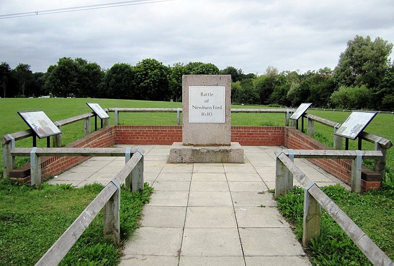
English: Monument commemorating the Battle of Newburn Ford, near to Newburn, Newcastle Upon Tyne, Great Britain.
In 1640 the tidal River Tyne could be forded at three points near Newburn. The Battle of Newburn Ford was a religion inspired battle prior to the English Civil War in 1640. At the battle, a Scottish Covenanters army of 20,000 men defeated a much smaller English force attempting to defend the fords, then went on to capture Newcastle. During the battle, the Scots used the height of the church tower to mount a canon
<a title="http://www.battlefieldstrust.com/resource-centre/civil-war/battleview.asp?BattleFieldId=29" rel="nofollow" href="http://www.battlefieldstrust.com/resource-centre/civil-war/battleview.asp?BattleFieldId=29">Link</a><img style="padding-left:2px;" alt="External link" title="External link - shift click to open in new window" src="http://s0.geograph.org.uk/img/external.png" width="10" height="10"/> <a title="http://www.newcastle.gov.uk/bofn.nsf/a/history" rel="nofollow" href="http://www.newcastle.gov.uk/bofn.nsf/a/history">Link</a><img style="padding-left:2px;" alt="External link" title="External link - shift click to open in new window" src="http://s0.geograph.org.uk/img/external.png" width="10" height="10"/> |
| Date | |
| Source | From geograph.org.uk; transferred by User:Fintan264 using geograph_org2commons. |
| Author | Andrew Curtis |
| Permission (Reusing this file) |
Creative Commons Attribution Share-alike license 2.0 |
| Camera location | | View this and other nearby images on: OpenStreetMap |
|---|
| Object location | | View this and other nearby images on: OpenStreetMap |
|---|
_region:GB-GBN_heading:0.00&language=en-gb)
Licensing

|
This image was taken from the Geograph project collection. See this photograph's page on the Geograph website for the photographer's contact details. The copyright on this image is owned by Andrew Curtis and is licensed for reuse under the Creative Commons Attribution-ShareAlike 2.0 license.
|
- You are free:
- to share – to copy, distribute and transmit the work
- to remix – to adapt the work
- Under the following conditions:
- attribution – You must give appropriate credit, provide a link to the licence, and indicate if changes were made. You may do so in any reasonable manner, but not in any way that suggests the licensor endorses you or your use.
- share alike – If you remix, transform, or build upon the material, you must distribute your contributions under the same or compatible licence as the original.
File history
Click on a date/time to view the file as it appeared at that time.
| Date/Time | Thumbnail | Dimensions | User | Comment | |
|---|---|---|---|---|---|
| current | 13:08, 28 August 2013 | | 995 × 672 (186 KB) | wikimediacommons>Soerfm | Crop, levels |
File usage
The following 3 pages use this file: