Moniloto de El Bodón.jpg
From Warlike

Size of this preview: 800 × 493 pixels. Other resolutions: 320 × 197 pixels | 640 × 394 pixels | 1,024 × 631 pixels | 1,280 × 788 pixels | 3,075 × 1,894 pixels.
Original file (3,075 × 1,894 pixels, file size: 3.5 MB, MIME type: image/jpeg)
Summary
| Description |
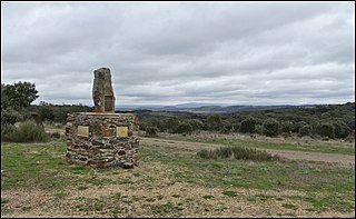
English: Standing stone and pedestal erected in 2011 to commemorate the bi-centenary of the combat of 25 September 1811, between the invading napoleonic army and the anglo-luso-germano coalition, which had to retreat due to the imbalance of force.
The French army, under command of Marmont, then moved to nearby Fuenteguinaldo and systematically ransacked the village : ►(File:Fuenteguinaldo, 1811-2011.jpg). |
| Date | |
| Source | Own work |
| Author | Alta Falisa |
| OpenStreetMap | Node 11532545717 |
| Object location | | View this and other nearby images on: OpenStreetMap |
|---|
| Camera location | | View this and other nearby images on: OpenStreetMap |
|---|
Road description : starting from (40.48719, -6.57660) in the village of El Bodón, (1) take a 500 m downhill road branching off c/ San Jose when leaving the village westwards, (2) go through a underpass under road CL-526, (3) then keep driving on a generally slightly uphill and sometimes bumpy earth road for 2300 m. The track is signposted whenever needed. (November 2019)
Licensing
I, the copyright holder of this work, hereby publish it under the following licence:
This file is licensed under the Creative Commons Attribution-Share Alike 4.0 International licence.
- You are free:
- to share – to copy, distribute and transmit the work
- to remix – to adapt the work
- Under the following conditions:
- attribution – You must give appropriate credit, provide a link to the licence, and indicate if changes were made. You may do so in any reasonable manner, but not in any way that suggests the licensor endorses you or your use.
- share alike – If you remix, transform, or build upon the material, you must distribute your contributions under the same or compatible licence as the original.
File history
Click on a date/time to view the file as it appeared at that time.
| Date/Time | Thumbnail | Dimensions | User | Comment | |
|---|---|---|---|---|---|
| current | 16:14, 15 April 2020 | | 3,075 × 1,894 (3.5 MB) | wikimediacommons>Alta Falisa | Uploaded own work with UploadWizard |
File usage
There are no pages that use this file.