MilneBayLocation.jpg
From Warlike

No higher resolution available.
MilneBayLocation.jpg (315 × 365 pixels, file size: 90 KB, MIME type: image/jpeg)

|
This locator map image could be re-created using vector graphics as an SVG file. This has several advantages; see Commons:Media for cleanup for more information. If an SVG form of this image is available, please upload it and afterwards replace this template with
{{vector version available|new image name}}.It is recommended to name the SVG file “MilneBayLocation.svg”—then the template Vector version available (or Vva) does not need the new image name parameter. |


Summary
== Summary ==
| Description |
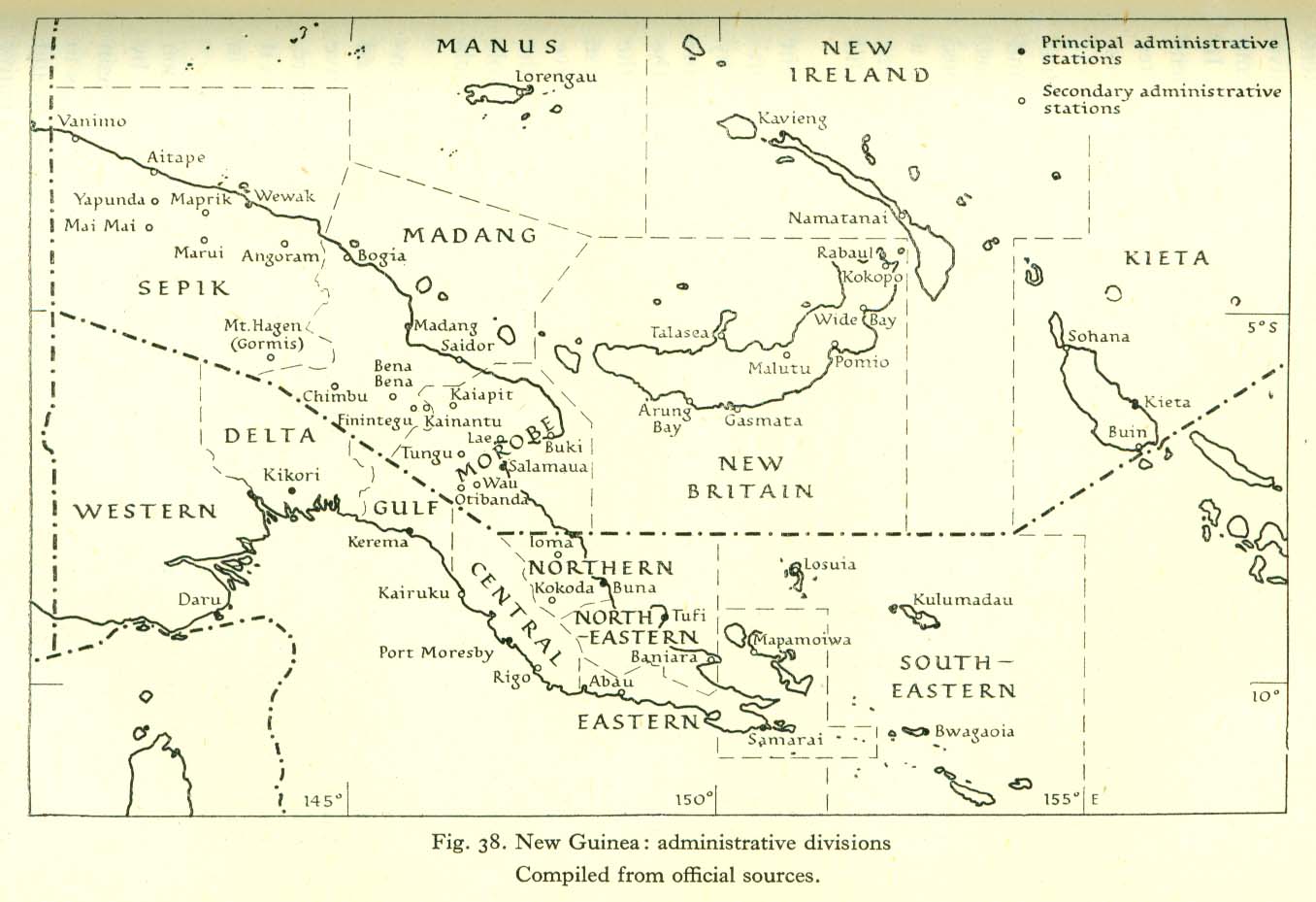
English: Map indicating location of Milne Bay within Papua andisland of New Guinea, also relative to Australia. |
| Date | |
| Source |
Own work created in Adobe Fireworks
|
| Author | Chris Rees User:SpoolWhippets |
Licensing
User:SpoolWhippets, the copyright holder of this work, hereby publishes it under the following licence:
This file is licensed under the Creative Commons Attribution-Share Alike 3.0 Unported licence.
Attribution:
- You are free:
- to share – to copy, distribute and transmit the work
- to remix – to adapt the work
- Under the following conditions:
- attribution – You must give appropriate credit, provide a link to the licence, and indicate if changes were made. You may do so in any reasonable manner, but not in any way that suggests the licensor endorses you or your use.
- share alike – If you remix, transform, or build upon the material, you must distribute your contributions under the same or compatible licence as the original.
Original upload log
Transferred from en.wikipedia to Commons using FtCG.
The original description page was here. All following user names refer to en.wikipedia.
| Date/Time | Dimensions | User | Comment |
|---|---|---|---|
| 12:30, 29 March 2010 | 315 × 365 (91,964 bytes) | w:en:SpoolWhippets (talk | contribs) | (Consistency with other PNG/Bougainville campaign maps. Reverted to 315 pixels wide.) |
| 13:12, 27 March 2010 | 610 × 730 (351,550 bytes) | w:en:SpoolWhippets (talk | contribs) | (Boxed detail area) |
| 03:19, 27 March 2010 | 610 × 730 (394,665 bytes) | w:en:SpoolWhippets (talk | contribs) | (Doubled size. Gave Rabaul capital star.) |
| 00:09, 27 March 2010 | 305 × 365 (252,127 bytes) | w:en:SpoolWhippets (talk | contribs) | (Removed Gona, added Buna - mentioned in Cyril Clowes article) |
| 00:05, 27 March 2010 | 305 × 365 (252,113 bytes) | w:en:SpoolWhippets (talk | contribs) | (cropped 10px on left) |
| 23:44, 26 March 2010 | 315 × 365 (253,923 bytes) | w:en:SpoolWhippets (talk | contribs) | (== {{int:filedesc}} == <br/>{{Information |Description=Map indicating location of Milne Bay within Papua andisland of New Guinea, also relative to Australia. |Source=Own work created in Adobe Fireworks<br/> *Data sources: **Coastlines: http://www.openstre) |
File history
Click on a date/time to view the file as it appeared at that time.
| Date/Time | Thumbnail | Dimensions | User | Comment | |
|---|---|---|---|---|---|
| current | 05:50, 24 May 2012 | | 315 × 365 (90 KB) | wikimediacommons>Addihockey10 | Transferred from en.wikipedia: see original upload log above |
File usage
There are no pages that use this file.