Kriegerdenkmal im Ahornwald auf der Gemarkung von Heckfeld.jpg
From Warlike

Size of this preview: 337 × 599 pixels. Other resolutions: 135 × 240 pixels | 270 × 480 pixels | 432 × 768 pixels | 576 × 1,024 pixels | 2,340 × 4,160 pixels.
Original file (2,340 × 4,160 pixels, file size: 3.5 MB, MIME type: image/jpeg)
Summary
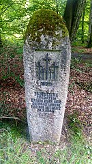
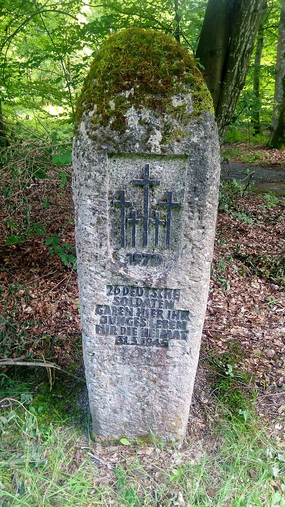
| Description | Kriegerdenkmal auf der Gemarkung von Heckfeld, einem Stadtteil von Lauda-Königshofen, im der Gemeinde Ahorn namensgebenden Waldstück Ahorn an der K2835 mit dem Logo des Volksbund Deutsche Kriegsgräberfürsorge e. V. und der Inschrift: 1970 26 DEUTSCHE SOLDATEN GABEN HIER IHR JUNGES LEBEN FÜR DIE HEIMAT 31.3.1945 |
| Date | 14 July 2019 (according to Exif data) |
| Source | Own work |
| Author | Granpar |
| OpenStreetMap | Node 6087875371 |
| Object location | | View this and other nearby images on: OpenStreetMap |
|---|
| Camera location | | View this and other nearby images on: OpenStreetMap |
|---|
.jpg)
Licensing
I, the copyright holder of this work, hereby publish it under the following licence:
This file is licensed under the Creative Commons Attribution-Share Alike 3.0 Unported licence.
- You are free:
- to share – to copy, distribute and transmit the work
- to remix – to adapt the work
- Under the following conditions:
- attribution – You must give appropriate credit, provide a link to the licence, and indicate if changes were made. You may do so in any reasonable manner, but not in any way that suggests the licensor endorses you or your use.
- share alike – If you remix, transform, or build upon the material, you must distribute your contributions under the same or compatible licence as the original.
| This file was uploaded via Mobile Android App (Commons mobile app) 2.10.2~66e1539a1. |
File history
Click on a date/time to view the file as it appeared at that time.
| Date/Time | Thumbnail | Dimensions | User | Comment | |
|---|---|---|---|---|---|
| current | 13:03, 15 July 2019 | | 2,340 × 4,160 (3.5 MB) | wikimediacommons>Granpar | Uploaded using Commons Mobile App |