Kinsale 1714 (Moll).jpg
From Warlike

Size of this preview: 800 × 566 pixels. Other resolutions: 320 × 226 pixels | 640 × 453 pixels | 1,024 × 724 pixels | 1,323 × 936 pixels.
Original file (1,323 × 936 pixels, file size: 213 KB, MIME type: image/jpeg)
Summary
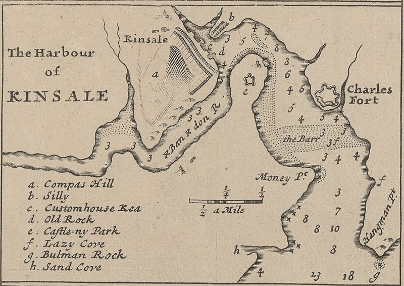
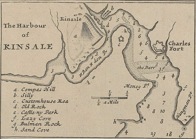
| English: The Harbour of Kinsale
( |
|||||||||||||||||||||||||||
|---|---|---|---|---|---|---|---|---|---|---|---|---|---|---|---|---|---|---|---|---|---|---|---|---|---|---|---|
| Author |
|
||||||||||||||||||||||||||
| Title |
English: The Harbour of Kinsale |
||||||||||||||||||||||||||
| Description |
English: A detail map of Kinsale c. 1714 from Moll's "A New Map of Ireland Divided into Its Provinces, Counties and Baronies...", sold separately or as part of The World Described... as p. 19.
|
||||||||||||||||||||||||||
| Date | 1714 | ||||||||||||||||||||||||||
| Dimensions |
Original Map: height: 64 cm; width: 105 cm |
||||||||||||||||||||||||||
| Collection |
|
||||||||||||||||||||||||||
| References |
Français : Notice de recueil : http://catalogue.bnf.fr/ark:/12148/cb40577015h
Appartient à : Collection d'Anville ; 02633 B Notice du catalogue : http://catalogue.bnf.fr/ark:/12148/cb406183087 |
||||||||||||||||||||||||||
| Source/Photographer |
Français : Bibliothèque nationale de France, département Cartes et plans, GE DD-2987 (2633 B)
Bibliothèque nationale de France |
||||||||||||||||||||||||||
| Other versions |
|
||||||||||||||||||||||||||


.jpg)
Licensing
This work is in the public domain in the United States because it was published (or registered with the U.S. Copyright Office) before January 1, 1930.
Public domain works must be out of copyright in both the United States and in the source country of the work in order to be hosted on the Commons. If the work is not a U.S. work, the file must have an additional copyright tag indicating the copyright status in the source country.
|
This work is in the public domain in France for one of the following reasons:
|
 |
| Annotations | This image is annotated: View the annotations at Commons |
File history
Click on a date/time to view the file as it appeared at that time.
| Date/Time | Thumbnail | Dimensions | User | Comment | |
|---|---|---|---|---|---|
| current | 16:52, 21 May 2023 | | 1,323 × 936 (213 KB) | wikimediacommons>LlywelynII | File:A New Map of Ireland Divided into its Provinces, Counties and Baronies, wherein are distinguished the Bishopricks, Borroughs, Barracks, Bogs, Passes, Bridges, &c. with the Principal Roads, and the common Reputed... - btv1b53057272q.jpg cropped using CropTool. |
File usage
There are no pages that use this file.
.jpg)