IDF-HTR-2000-rifle-ZE001.jpg
From Warlike

Size of this preview: 800 × 259 pixels. Other resolutions: 320 × 103 pixels | 640 × 207 pixels | 1,024 × 331 pixels | 1,280 × 414 pixels | 3,564 × 1,152 pixels.
Original file (3,564 × 1,152 pixels, file size: 571 KB, MIME type: image/jpeg)
Summary
| Description |
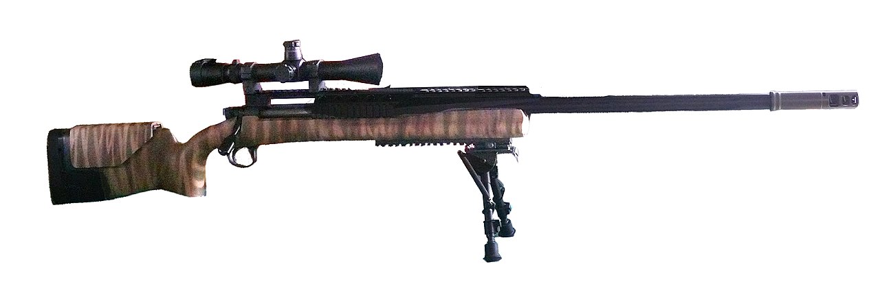
English: Israel Defense Forces "Barak" H-S Precision Pro Series 2000 HTR sniper rifle עברית: רובה צלפים "ברק" HTR 2000 של צבא ההגנה לישראל
English: H-S Precision Pro Series 2000 HTR sniper rifle of the Israel Defense Forces
Called "Barak" by the IDF, this 0.338 Lapua sniper rifle can deliever a 0.5 MOA group at a distance over 1200 meters. First used by IDF during "Operation Cast Lead" in 2009, the Israeli-converted American sniper rifle, performed superbly, hitting terrorist targets from large distances. Operation Cast Lead was a counter-terrorism mission against Hamas' barrage of Grad 122mm rockets over Israeli cities, in which at least 709 terrorists were killed (out of about 1160 Palestinian deads).
עברית: רובה צלפים
Photo by Zachi Evenor and MathKnightHTR 2000 של צה"ל רובה ה"ברק" של צה"ל הוא רובה צלפים בקליבר 0.338 לפואה שיכול לפגוע בדיוק של 0.5 דקת קשת ממרחק של יותר מ-1200 מטר. ה"ברק" רשם טבילת אש מבצעית במבצע עופרת יצוקה ב-2009 והשיג תוצאות מצוינות כאשר פגע בדיוק רב במטרות טרור ממרחק רב. מבצע עופרת יצוקה היה מבצע צבאי נגד טרור בו פעל צה"ל לעצירת מטחי רקטות הגראד שירה חמאס על ערי ישראל. במבצע נהרגו לפחות 709 מחבלים (סך הכל נהרגו כ- 1160 פלסטינים). י |
| Date | |
| Source | Flickr: https://www.flickr.com/photos/zachievenor/6934450276/in/photostream |
| Author | Zachi Evenor and MathKnight |
| Camera location | | View this and other nearby images on: OpenStreetMap |
|---|
|
|
|
|
This file is licensed under the Creative Commons Attribution-Share Alike 4.0 International licence.
|
Licensing
| This image was originally posted to Flickr by Zachi Evenor at https://www.flickr.com/photos/40794167@N05/6934450276. It was reviewed on 15 April 2012 by FlickreviewR and was confirmed to be licensed under the terms of the cc-by-2.0. |
This file is licensed under the Creative Commons Attribution 2.0 Generic licence.
- You are free:
- to share – to copy, distribute and transmit the work
- to remix – to adapt the work
- Under the following conditions:
- attribution – You must give appropriate credit, provide a link to the licence, and indicate if changes were made. You may do so in any reasonable manner, but not in any way that suggests the licensor endorses you or your use.
File history
Click on a date/time to view the file as it appeared at that time.
| Date/Time | Thumbnail | Dimensions | User | Comment | |
|---|---|---|---|---|---|
| current | 17:06, 15 April 2012 | 3,564 × 1,152 (571 KB) | wikimediacommons>MathKnight | minor corrections |
File usage
There are no pages that use this file.