GIUK gap.png
From Warlike

Size of this preview: 495 × 599 pixels. Other resolutions: 198 × 240 pixels | 397 × 480 pixels | 635 × 768 pixels | 1,024 × 1,239 pixels.
Original file (1,024 × 1,239 pixels, file size: 769 KB, MIME type: image/png)

|
This map image could be re-created using vector graphics as an SVG file. This has several advantages; see Commons:Media for cleanup for more information. If an SVG form of this image is available, please upload it and afterwards replace this template with
{{vector version available|new image name}}.It is recommended to name the SVG file “GIUK gap.svg”—then the template Vector version available (or Vva) does not need the new image name parameter. |
Summary
| Description | This is a PNG version of "Guik gap.gif" as it appeared on the English Wikipedia. As it has been recommended that the GIF version is replaced by a PNG or SVG version, I converted the original GIF to PNG and uploaded it to Wikimedia Commons instead. All I have done is convert the image to PNG, and rename it to "GIUK_gap" instead of "Guik gap", in correspondance with the Wikipedia article on the GIUK gap. |
| Source | https://www.cia.gov/csi/monograph/coldwar/pg9.gif |
| Author | |
| Other versions | http://en.wikipedia.org/wiki/Image:Guik_gap.gif |
Original GIF summary
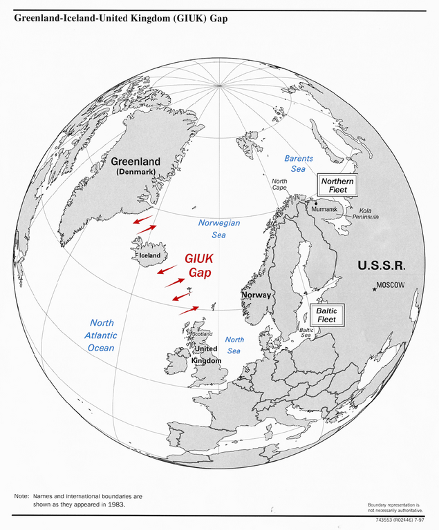
The GIUK gap is an area in the northern Atlantic Ocean that forms a naval warfare chokepoint. Its name is an acronym for Greenland, Iceland, and the United Kingdom, the gap being the open ocean between these three landmasses. The term is typically used in military topics.
source: https://www.cia.gov/csi/monograph/coldwar/pg9.gif archive copy at the Wayback Machine
Licensing
This work is in the public domain in the United States because it is a work prepared by an officer or employee of the United States Government as part of that person’s official duties under the terms of Title 17, Chapter 1, Section 105 of the US Code.
Note: This only applies to original works of the Federal Government and not to the work of any individual U.S. state, territory, commonwealth, county, municipality, or any other subdivision. This template also does not apply to postage stamp designs published by the United States Postal Service since 1978. (See § 313.6(C)(1) of Compendium of U.S. Copyright Office Practices). It also does not apply to certain US coins; see The US Mint Terms of Use.
|
 | |
| This file has been identified as being free of known restrictions under copyright law, including all related and neighbouring rights. | ||
File history
Click on a date/time to view the file as it appeared at that time.
| Date/Time | Thumbnail | Dimensions | User | Comment | |
|---|---|---|---|---|---|
| current | 21:34, 12 September 2023 | | 1,024 × 1,239 (769 KB) | wikimediacommons>Hohum | Colours for clarity |
File usage
There are no pages that use this file.