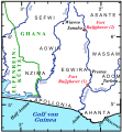
Fort Ruijghaver 010.svg
From Warlike
File:Fort Ruijghaver 010.svg

Size of this PNG preview of this SVG file: 554 × 599 pixels. Other resolutions: 222 × 240 pixels | 444 × 480 pixels | 710 × 768 pixels | 947 × 1,024 pixels | 1,894 × 2,048 pixels | 727 × 786 pixels.
Original file (SVG file, nominally 727 × 786 pixels, file size: 384 KB)
File history
Click on a date/time to view the file as it appeared at that time.
| Date/Time | Thumbnail | Dimensions | User | Comment | |
|---|---|---|---|---|---|
| current | 20:22, 9 December 2011 |  | 727 × 786 (384 KB) | wikimediacommons>Katharinaiv | {{Information |Description ={{en|1=Map to the possible location of the Dutch fort Ruijghaver, 1654 - 1660, at the river Akobra.}} {{de|1=Karte zur möglichen Lage des holländischen Forts Ruijghaver, 1654 - 1660, am Akobrafluss.}} |Source ={{ow |
File usage
The following 3 pages use this file: