First Canadian patrol entering Valenciennes from the West (4687970495).jpg
From Warlike
Size of this preview: 769 × 600 pixels. Other resolutions: 308 × 240 pixels | 616 × 480 pixels | 985 × 768 pixels | 1,280 × 998 pixels | 2,500 × 1,949 pixels.
Original file (2,500 × 1,949 pixels, file size: 698 KB, MIME type: image/jpeg)
.jpg)
Summary
| Description |
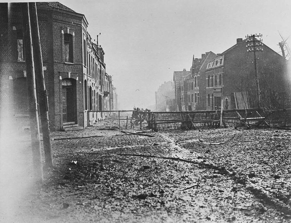
English: Among the most haunting images of the Haig collection are those photographs taken in towns near the front line. Some are in ruins, others, like Valenciennes in this picture, seem relatively untouched, but almost all project a ghost-town atmosphere. In this photograph the only humans daring to be seen are the patrolling Canadian soldiers. We know from the original caption that somewhere out of sight, German machine-gunners are waiting. Valenciennes lies to the north-east of Cambrai, in the Hainaut region of France. The town was near the front line during the Allied offensives of late summer and Autumn 1918, and the final week of the war started with an Allied push from Valenciennes towards Sambre-Oise Canal on November 4th 1918. |
| Date | |
| Source | https://www.flickr.com/photos/nlscotland/4687970495/ |
| Author | National Library of Scotland |
| Permission (Reusing this file) |
At the time of upload, the image license was automatically confirmed using the Flickr API. For more information see Flickr API detail. |
| Flickr sets |
|
| Flickr tags |
|
| Camera location | | View this and other nearby images on: OpenStreetMap |
|---|
.jpg¶ms=050.358489_N_0003.524100_E_globe:Earth_type:camera__&language=en-gb)
Licensing
This image was taken from Flickr's The Commons. The uploading organization may have various reasons for determining that no known copyright restrictions exist, such as:
More information can be found at https://flickr.com/commons/usage/. Please add additional copyright tags to this image if more specific information about copyright status can be determined. See Commons:Licensing for more information. |
| This image was originally posted to Flickr by National Library of Scotland at https://flickr.com/photos/14456531@N07/4687970495. It was reviewed on 16 November 2016 by FlickreviewR and was confirmed to be licensed under the terms of the No known copyright restrictions. |
File history
Click on a date/time to view the file as it appeared at that time.
| Date/Time | Thumbnail | Dimensions | User | Comment | |
|---|---|---|---|---|---|
| current | 12:35, 11 December 2025 | | 2,500 × 1,949 (698 KB) | wikimediacommons>Ich | larger (from nls) |
File usage
There are no pages that use this file.
.jpg)