Döbling (Wien) - Habsburgwarte.JPG
From Warlike

Size of this preview: 400 × 600 pixels. Other resolutions: 160 × 240 pixels | 320 × 480 pixels | 512 × 768 pixels | 683 × 1,024 pixels | 1,366 × 2,048 pixels | 2,678 × 4,016 pixels.
Original file (2,678 × 4,016 pixels, file size: 9.02 MB, MIME type: image/jpeg)
_-_Habsburgwarte.JPG)
Summary
| Description |
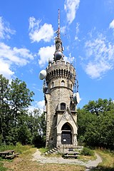
Deutsch: Westansicht der Habsburgwarte im 19. Wiener Gemeindebezirk Döbling.
Die Aussichtswarte wurde anlässlich des 40-jährigen Regierungsjubiläums von Kaiser Franz Joseph I. 1888 vom Österreichischen Touristenklub auf Wiens höchstem Berg, dem 542 Meter hohen Hermannskogel, errichtet. Im Zuge der österreichischen Landesvermessung 1892 wurde vom k. u. k. Militärgeographischen Institut auf der Warte ein Pfeiler errichtet, auf dem sich der Fundamental- bzw. Triangulierungshauptpunkt des österreichischen Festpunktfeldes befindet. |
| Date | |
| Source | Own work |
| Author | C.Stadler/Bwag |
| Permission (Reusing this file) |
Deutsch: Hallo, du darfst meine Fotos kostenlos nutzen, aber nenne mich bitte als Fotograf, beispielsweise „Foto: C.Stadler/Bwag“ oder © C.Stadler/Bwag; CC-BY-SA-4.0. Auf mehr Angaben bestehe ich nicht - im Gegensatz zu manch anderen, die die Vorgaben der unten angeführten Lizenzierung auf Punkt und Beistrich einfordern. English: Feel free to use my photos, but please mention me as the author like © C.Stadler/Bwag or © C.Stadler/Bwag; CC-BY-SA-4.0 (that's good enough) and if you want send me a message: bwag@gmx.net. |
| Camera location | | View this and other nearby images on: OpenStreetMap |
|---|
_-_Habsburgwarte.JPG¶ms=048.270272_N_0016.293658_E_globe:Earth_type:camera_alt:564.2_source:exif_&language=en-gb)
| Object location | | View this and other nearby images on: OpenStreetMap |
|---|
_-_Habsburgwarte.JPG¶ms=048.270000_N_0016.293611_E_globe:Earth_class:object_type:object_region:AT-9_&language=en-gb)
Licensing
I, the copyright holder of this work, hereby publish it under the following licence:
This file is licensed under the Creative Commons Attribution-Share Alike 4.0 International licence.
- You are free:
- to share – to copy, distribute and transmit the work
- to remix – to adapt the work
- Under the following conditions:
- attribution – You must give appropriate credit, provide a link to the licence, and indicate if changes were made. You may do so in any reasonable manner, but not in any way that suggests the licensor endorses you or your use.
- share alike – If you remix, transform, or build upon the material, you must distribute your contributions under the same or compatible licence as the original.
File history
Click on a date/time to view the file as it appeared at that time.
| Date/Time | Thumbnail | Dimensions | User | Comment | |
|---|---|---|---|---|---|
| current | 16:56, 21 July 2015 | | 2,678 × 4,016 (9.02 MB) | wikimediacommons>Bwag | {{Information |Description= {{de|1=Westansicht der Habsburgwarte im 19. Wiener Gemeindebezirk Döbling.<br/>Die Aussichtswarte wurde anlässlich des 40-jährigen Regierungsjubiläums von Kaiser Franz... |
File usage
There are no pages that use this file.
_-_Habsburgwarte.JPG)