Concord Expedition and Patriot Messengers.jpg
From Warlike

Size of this preview: 800 × 341 pixels. Other resolutions: 320 × 136 pixels | 1,000 × 426 pixels.
Original file (1,000 × 426 pixels, file size: 139 KB, MIME type: image/jpeg)

|
This file has been superseded by Concord Expedition and Patriot Messengers-en.svg. It is recommended to use the other file. Please note that deleting superseded images requires consent.
|

|
File:Concord Expedition and Patriot Messengers-en.svg is a vector version of this file. It should be used in place of this JPG file when not inferior.
File:Concord Expedition and Patriot Messengers.jpg → File:Concord Expedition and Patriot Messengers-en.svg
For more information, see Help:SVG. |
 |
Summary
| Title |
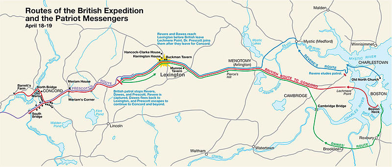
English: Routes of the British Expedition and the Patriot Messengers |
|||||||||||||||||||||||
| Description |
Paul Revere's Midnight Ride English: This is a map depiction the outbound routes taken by Patriot riders and British troops in the Battles of Lexington and Concord on April 19, 1775. |
|||||||||||||||||||||||
| Map legend |
British route to Concord Revere's route Dawes' route Prescott's route |
|||||||||||||||||||||||
| Date | Unknown date; source PDF was created in 2000 | |||||||||||||||||||||||
| Source | MIMAmap2.pdf 10 May 2005 (upload date) by w:Flying Jazz (talk | contribs) | |||||||||||||||||||||||
| Creator |
Unknown author for National Park Service |
|||||||||||||||||||||||
| Geotemporal data | ||||||||||||||||||||||||
| Date depicted | ||||||||||||||||||||||||
| Map location | Boston, Massachusetts | |||||||||||||||||||||||
| Map type | thematic map | |||||||||||||||||||||||
| Heading |
 |
|||||||||||||||||||||||
| Georeferencing | If inappropriate please set warp_status = skip to hide. | |||||||||||||||||||||||
| Bibliographic data | ||||||||||||||||||||||||
| Publisher |
National Park Service |
|||||||||||||||||||||||
| Archival data | ||||||||||||||||||||||||
| Collection |
|
|||||||||||||||||||||||
| Inscriptions |
Title :
Routes of the British Expedition and the Patriot Messengers
Text :
Revere and Dawes reach Lexington before British leave Lechmere Point. Dr. Prescott joins them after they leave for Concord.
Text :
British patrol stops Revere, Dawes, and Prescott. Revere is captured, Dawes flees back to Lexington, and Prescott escapes to continue to Concord and beyond.
|
|||||||||||||||||||||||
| Other versions |
|
|||||||||||||||||||||||

Licensing
| This image or media file contains material based on a work of a National Park Service employee, created as part of that person's official duties. As a work of the U.S. federal government, such work is in the public domain in the United States. See the NPS website and NPS copyright policy for more information. |
Original upload log
Transferred from en.wikipedia to Commons by Andrei Stroe using CommonsHelper.
The original description page was here. All following user names refer to en.wikipedia.
- 2005-05-10 09:58 Flying Jazz 1000×426× (141988 bytes) Routes of the British Expedition and the Patriot Messengers April 18-19 (1775) Minute Man National Historical Park Battle Map http://data2.itc.nps.gov/parks/mima/ppMaps/MIMAmap2.pdf {{PD-USGov-Interior-NPS}}
- 2005-05-10 09:54 Flying Jazz 1000×426× (141988 bytes) Minute Man National Historical Park Battle Map http://data2.itc.nps.gov/parks/mima/ppMaps/MIMAmap2.pdf {{PD-USGov-Interior-NPS}}
File history
Click on a date/time to view the file as it appeared at that time.
| Date/Time | Thumbnail | Dimensions | User | Comment | |
|---|---|---|---|---|---|
| current | 20:50, 22 November 2010 | | 1,000 × 426 (139 KB) | wikimediacommons>File Upload Bot (Magnus Manske) | {{BotMoveToCommons|en.wikipedia|year={{subst:CURRENTYEAR}}|month={{subst:CURRENTMONTHNAME}}|day={{subst:CURRENTDAY}}}} {{Information |Description={{en|This is a map depiction the outbound routes taken by Patriot ride |
File usage
There are no pages that use this file.