Cape May, New Jersey 1777.jpg
From Warlike
File:Cape May, New Jersey 1777.jpg
Size of this preview: 702 × 600 pixels. Other resolutions: 281 × 240 pixels | 562 × 480 pixels | 899 × 768 pixels | 1,198 × 1,024 pixels | 1,830 × 1,564 pixels.
Original file (1,830 × 1,564 pixels, file size: 1.02 MB, MIME type: image/jpeg)
Summary
| English: The Province of New Jersey, divided into East and West, commonly called the Jerseys. Engraved & published by Wm. Faden. | |||||||||||||||||||||||||||||||||||||||||||||
|---|---|---|---|---|---|---|---|---|---|---|---|---|---|---|---|---|---|---|---|---|---|---|---|---|---|---|---|---|---|---|---|---|---|---|---|---|---|---|---|---|---|---|---|---|---|
| Artist |
Engraved by
|
||||||||||||||||||||||||||||||||||||||||||||
| Title |
English: The Province of New Jersey, divided into East and West, commonly called the Jerseys. Engraved & published by Wm. Faden. |
||||||||||||||||||||||||||||||||||||||||||||
| Description |
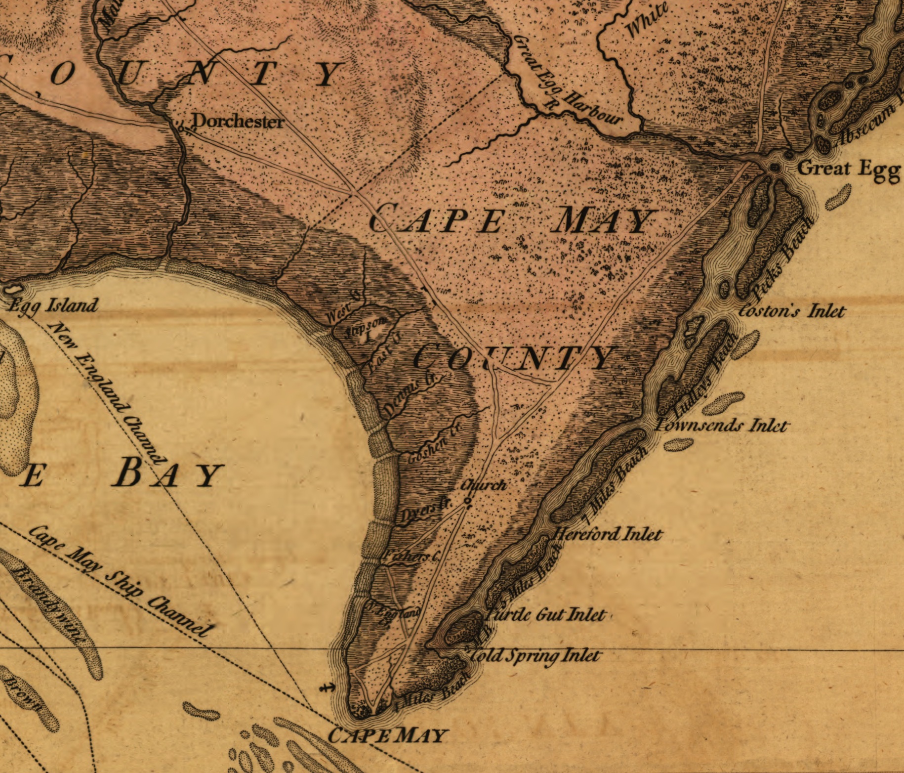
English: Detail of a 1777 map depicting Cape May County, New Jersey. The area shown was the scene of military activity, the Battle of Turtle Gut Inlet, early in the American Revolutionary War. |
||||||||||||||||||||||||||||||||||||||||||||
| Date | 1777 | ||||||||||||||||||||||||||||||||||||||||||||
| Notes |
Shows county boundaries and "Division line run in 1743 between East New Jersey and West New Jersey." "This map has been drawn from the survey made in 1769 ... by Bernard Ratzer ... and from another large survey of the northern parts ... by Gerard Banker." Appears in William Faden's The North American atlas. 1777. Reference: LC Maps of North America, 1750-1789, 1238 |
||||||||||||||||||||||||||||||||||||||||||||
| Source/Photographer |
|
||||||||||||||||||||||||||||||||||||||||||||
| Other versions | |||||||||||||||||||||||||||||||||||||||||||||


Licensing
This media file is in the public domain in the United States. This applies to U.S. works where the copyright has expired, often because its first publication occurred prior to January 1, 1929, and if not then due to lack of notice or renewal. See this page for further explanation.
|
 | |
 |
File history
Click on a date/time to view the file as it appeared at that time.
| Date/Time | Thumbnail | Dimensions | User | Comment | |
|---|---|---|---|---|---|
| current | 18:55, 1 April 2012 | | 1,830 × 1,564 (1.02 MB) | wikimediacommons>Zeete |
File usage
The following 4 pages use this file: