Battle of Daraa City.svg
From Warlike

Size of this PNG preview of this SVG file: 600 × 600 pixels. Other resolutions: 240 × 240 pixels | 480 × 480 pixels | 768 × 768 pixels | 1,024 × 1,024 pixels | 2,048 × 2,048 pixels | 1,500 × 1,500 pixels.
Original file (SVG file, nominally 1,500 × 1,500 pixels, file size: 2.8 MB)
Summary
| Description |
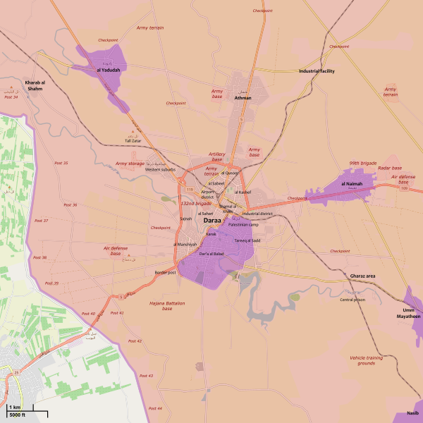
English: Map showing the current strategic situation in Daraa City.
العربية: .خريطة تظهر الحالة الإستراتيجية في مدينا درعا
Syrian Arab Republic full control
Reconciled rebels control (no Syrian Government presence)
Reconciled rebels control (with Syrian Government presence) |
||||
| Date | |||||
| Source | Own work | ||||
| Author | MrPenguin20 | ||||
| Other versions |
|
||||
| SVG genesis |


.svg)


.svg)

.svg)
.svg)


_Territory_Change_2014-2016.gif)

_(within_Northern_Syria).svg)


.png)
.svg)


_map.png)
.svg)
.svg)


.svg)


Licensing
I, the copyright holder of this work, hereby publish it under the following licence:
This file is licensed under the Creative Commons Attribution-Share Alike 3.0 Unported licence.
- You are free:
- to share – to copy, distribute and transmit the work
- to remix – to adapt the work
- Under the following conditions:
- attribution – You must give appropriate credit, provide a link to the licence, and indicate if changes were made. You may do so in any reasonable manner, but not in any way that suggests the licensor endorses you or your use.
- share alike – If you remix, transform, or build upon the material, you must distribute your contributions under the same or compatible licence as the original.
| This work contains information from OpenStreetMap, which is made available under the Open Database License (ODbL).
The ODbL does not require any particular license for maps produced from ODbL data. Prior to 1 August 2020, map tiles produced by the OpenStreetMap Foundation were licensed under the CC-BY-SA-2.0 license. Maps produced by other people may be subject to other licences. |
File history
Click on a date/time to view the file as it appeared at that time.
| Date/Time | Thumbnail | Dimensions | User | Comment | |
|---|---|---|---|---|---|
| current | 17:26, 19 September 2021 | | 1,500 × 1,500 (2.8 MB) | wikimediacommons>Rr016 | Update. Syrian Army forced new agreement for Daraa Al-Balad (Sept. 5), Al-Yadudah (Sept. 13), Muzayrib (Sept. 16), and Tafas (Sept. 18)) |
File usage
The following 5 pages use this file: