Banat Josephinische Landaufnahme pg178.jpg
From Warlike

Size of this preview: 800 × 543 pixels. Other resolutions: 320 × 217 pixels | 640 × 434 pixels | 1,024 × 695 pixels | 1,280 × 868 pixels | 2,560 × 1,737 pixels | 8,419 × 5,712 pixels.
Original file (8,419 × 5,712 pixels, file size: 26.52 MB, MIME type: image/jpeg)
| Name shown on the map Nume din hartă |
Administrative unit Unitate administrativă |
Romanian name Numele românesc |
Hungarian name Numele unguresc |
German name Numele german |
Serbian name Numele sârbesc |
Country today Ţara de astăzi |
|---|---|---|---|---|---|---|
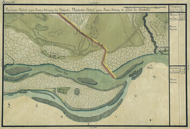
| Dubovatz | Német bánsági ezred | Dubovac | Dunadombó | Dubowatz | Дубовац, Dubovac | Szerbia és Montenegró |
| Uypalanka | Oláh-illír bánsági ezred (Román-illír bánsági kerület) | Banatska Palanka (Stara Palanka) | Ó-Palánka, Palánk, Temespalánka (Újpalánka) | Neu-Palanka und Alt-Palanka | Банатска Паланка, Banatska Palanka, Stara Palanka | Szerbia és Montenegró |
Summary
| Description |
Deutsch: Das Banat in: Josephinische Landesaufnahme, 1769-72. Josephinische Landaufnahme pg178 English: The Banat region in the cadastral maps: Josephinische Landesaufnahme, 1769-72. Josephinische Landaufnahme pg178 |
||||
| Date | between 1769 and 1772 | ||||
| Source | Österreichisches Staatsarchiv, Kriegsarchiv | ||||
| Author | Historische Militärkarte der österreichisch-ungarischen Monarchie | ||||
| Permission (Reusing this file) |
|
||||
Clickable map of the Banat region

File history
Click on a date/time to view the file as it appeared at that time.
| Date/Time | Thumbnail | Dimensions | User | Comment | |
|---|---|---|---|---|---|
| current | 07:19, 5 January 2010 | | 8,419 × 5,712 (26.52 MB) | wikimediacommons>Asybaris01 | {{Information |Description={{ro|1=Banat Josephinische Landaufnahme pg178}} |Source={{own}} |Author=Asybaris01 |Date=1769-72 |Permission= |other_versions= }} Category:Josephinische Landaufnahme |
File usage
There are no pages that use this file.