Balearic Sea map.png
From Warlike
Size of this preview: 800 × 511 pixels. Other resolutions: 320 × 204 pixels | 640 × 409 pixels | 1,000 × 639 pixels.
Original file (1,000 × 639 pixels, file size: 77 KB, MIME type: image/png)
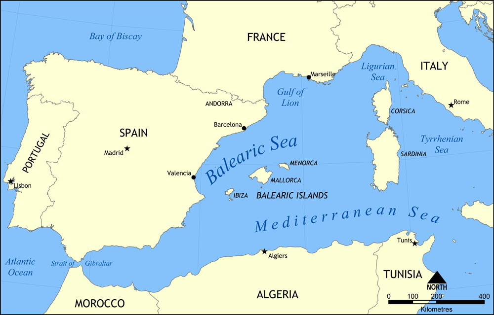
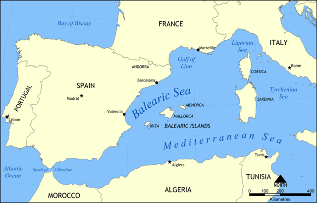
Map showing the location of the Balearic Sea, part of the Mediterranean Sea.
Created by NormanEinstein, May 26, 2006.
I, the copyright holder of this work, hereby publish it under the following licence:

|
Permission is granted to copy, distribute and/or modify this document under the terms of the GNU Free Documentation Licence, Version 1.2 or any later version published by the Free Software Foundation; with no Invariant Sections, no Front-Cover Texts, and no Back-Cover Texts. A copy of the licence is included in the section entitled GNU Free Documentation Licence. |
| This file is licensed under the Creative Commons Attribution-Share Alike 3.0 Unported licence. | ||
| ||
| This licensing tag was added to this file as part of the GFDL licensing update. |
File history
Click on a date/time to view the file as it appeared at that time.
| Date/Time | Thumbnail | Dimensions | User | Comment | |
|---|---|---|---|---|---|
| current | 15:31, 26 May 2006 | | 1,000 × 639 (77 KB) | wikimediacommons>NormanEinstein | Map showing the location of the Balearic Sea, part of the Mediterranean Sea. Created by NormanEinstein, May 26, 2006. {{GFDL-self}} Category:Maps of seas |
File usage
The following 58 pages use this file:
- Couvreport Battery
- Crutchett's Batteries
- Devil's Tongue Battery
- Europa Batteries
- Farringdon's Battery
- Gardiner's Battery
- Grand Battery
- Green's Lodge Battery
- Harding's Battery
- Lord Airey's Battery
- Queen Charlotte's Battery
- Rooke Battery
- Rosia Batteries
- Saluting Battery
- Spyglass Battery
- Tovey Battery
- Zoca Flank Battery
- naval battle
- Buffadero Battery
- Civil Hospital Battery
- Cumberland Flank Battery
- Devil's Bowling Green Battery
- Engineer Battery
- Europa Advance Batteries
- Europa Pass Batteries
- Governor's Lookout Battery
- Half Way Battery
- Jones' Battery
- King's Lines Battery
- Martin's Battery
- Prince Ferdinand's Battery
- Raglan's Battery
- Signal Hill Battery
- South Batteries
- Calpe Battery
- Catalan Batteries
- Edward VII Battery
- Eliott's Battery
- Eliott's Practice Battery
- Genista Battery
- Genoese Batteries
- Hutment Battery
- Victoria Battery
- Princess Anne's Battery
- Princess Royal's Battery
- Napier of Magdala Battery
- 1800s
- Action of 19 February 1801
- Spur Battery
- Breakneck Battery
- Devil's Gap Battery
- Levant Battery
- Middle Hill Battery
- 1801
- O'Hara's Battery
- Princess Amelia's Battery
- Rock Gun Battery
- Princess Caroline's Battery