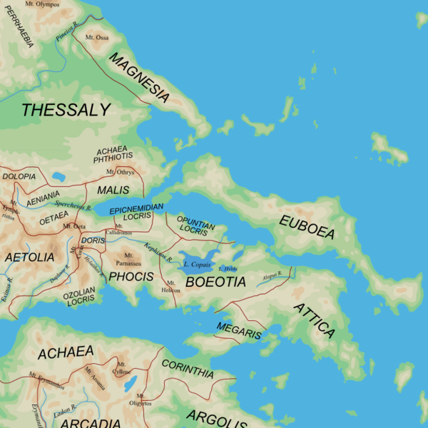
Ancient Regions Central Greece.png
From Warlike
File:Ancient Regions Central Greece.png

Size of this preview: 600 × 600 pixels. Other resolutions: 240 × 240 pixels | 480 × 480 pixels.
Original file (800 × 800 pixels, file size: 393 KB, MIME type: image/png)
| Description |
English: Map of the central regions of Ancient Greece |
| Date | (UTC) |
| Source |
|
| Author | User:MinisterForBadTimes |
| Other versions |
Derivative works of this file: |
| This is a retouched picture, which means that it has been digitally altered from its original version. The original can be viewed here: Ancient Greek southern regions.png:
|
I, the copyright holder of this work, hereby publish it under the following licences:
This file is licensed under the Creative Commons Attribution-Share Alike 2.5 Generic licence.
- You are free:
- to share – to copy, distribute and transmit the work
- to remix – to adapt the work
- Under the following conditions:
- attribution – You must give appropriate credit, provide a link to the licence, and indicate if changes were made. You may do so in any reasonable manner, but not in any way that suggests the licensor endorses you or your use.
- share alike – If you remix, transform, or build upon the material, you must distribute your contributions under the same or compatible licence as the original.
| This file is licensed under the Creative Commons Attribution-Share Alike 3.0 Unported licence. | ||
| ||
| This licensing tag was added to this file as part of the GFDL licensing update. |

|
Permission is granted to copy, distribute and/or modify this document under the terms of the GNU Free Documentation Licence, Version 1.2 or any later version published by the Free Software Foundation; with no Invariant Sections, no Front-Cover Texts, and no Back-Cover Texts. A copy of the licence is included in the section entitled GNU Free Documentation Licence. |
You may select the licence of your choice.
Original upload log
This image is a derivative work of the following images:
- File:Ancient_Greek_southern_regions.png licensed with Cc-by-sa-2.5, Cc-by-sa-3.0-migrated, GFDL
- 2010-01-12T08:44:56Z MinisterForBadTimes 800x800 (385822 Bytes) {{Information |Description={{en|Map of the regions of Ancient Greece}} |Source=*[[:File:Map_greek_sanctuaries-en.svg|]]. Geographical information based on public domain map of Greece, from the Perry-Castañeda Library Map Col
Uploaded with derivativeFX
File history
Click on a date/time to view the file as it appeared at that time.
| Date/Time | Thumbnail | Dimensions | User | Comment | |
|---|---|---|---|---|---|
| current | 20:41, 3 March 2010 | | 800 × 800 (393 KB) | wikimediacommons>MinisterForBadTimes | Two spellings corrected |