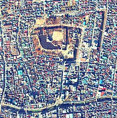
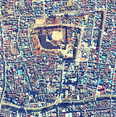
Aerial view of Matsumoto Castle.jpg
From Warlike

Size of this preview: 595 × 599 pixels. Other resolutions: 238 × 240 pixels | 477 × 480 pixels | 762 × 768 pixels | 1,098 × 1,106 pixels.
Original file (1,098 × 1,106 pixels, file size: 1.92 MB, MIME type: image/jpeg)
Summary
| Description |
日本語: 松本城上空の空中写真。国土交通省の空中写真ccb-75-15_c8_11から作成。 |
| Date | |
| Source | 国土情報ウェブマッピングシステム |
| Author | 国土交通省 |
| Camera location | | View this and other nearby images on: OpenStreetMap |
|---|
Licensing

|
The copyright holder of this file, Ministry of Land, Infrastructure, Transport and Tourism, allows anyone to use it for any purpose, provided that the copyright holder is properly attributed. Redistribution, derivative work, commercial use, and all other use is permitted. |
Attribution:
Copyright © National Land Image Information (Color Aerial Photographs), Ministry of Land, Infrastructure, Transport and Tourism
|
File history
Click on a date/time to view the file as it appeared at that time.
| Date/Time | Thumbnail | Dimensions | User | Comment | |
|---|---|---|---|---|---|
| current | 13:44, 6 October 2020 | | 1,098 × 1,106 (1.92 MB) | wikimediacommons>名古屋太郎 | 画質修正、EXIFデータ修正 |
File usage
There are no pages that use this file.