2. লালবাগের কেল্লা.jpg
From Warlike
Size of this preview: 800 × 533 pixels. Other resolutions: 320 × 213 pixels | 640 × 427 pixels | 1,024 × 683 pixels | 1,280 × 854 pixels | 2,560 × 1,707 pixels | 4,787 × 3,192 pixels.
Original file (4,787 × 3,192 pixels, file size: 12.07 MB, MIME type: image/jpeg)
Summary
| Description |
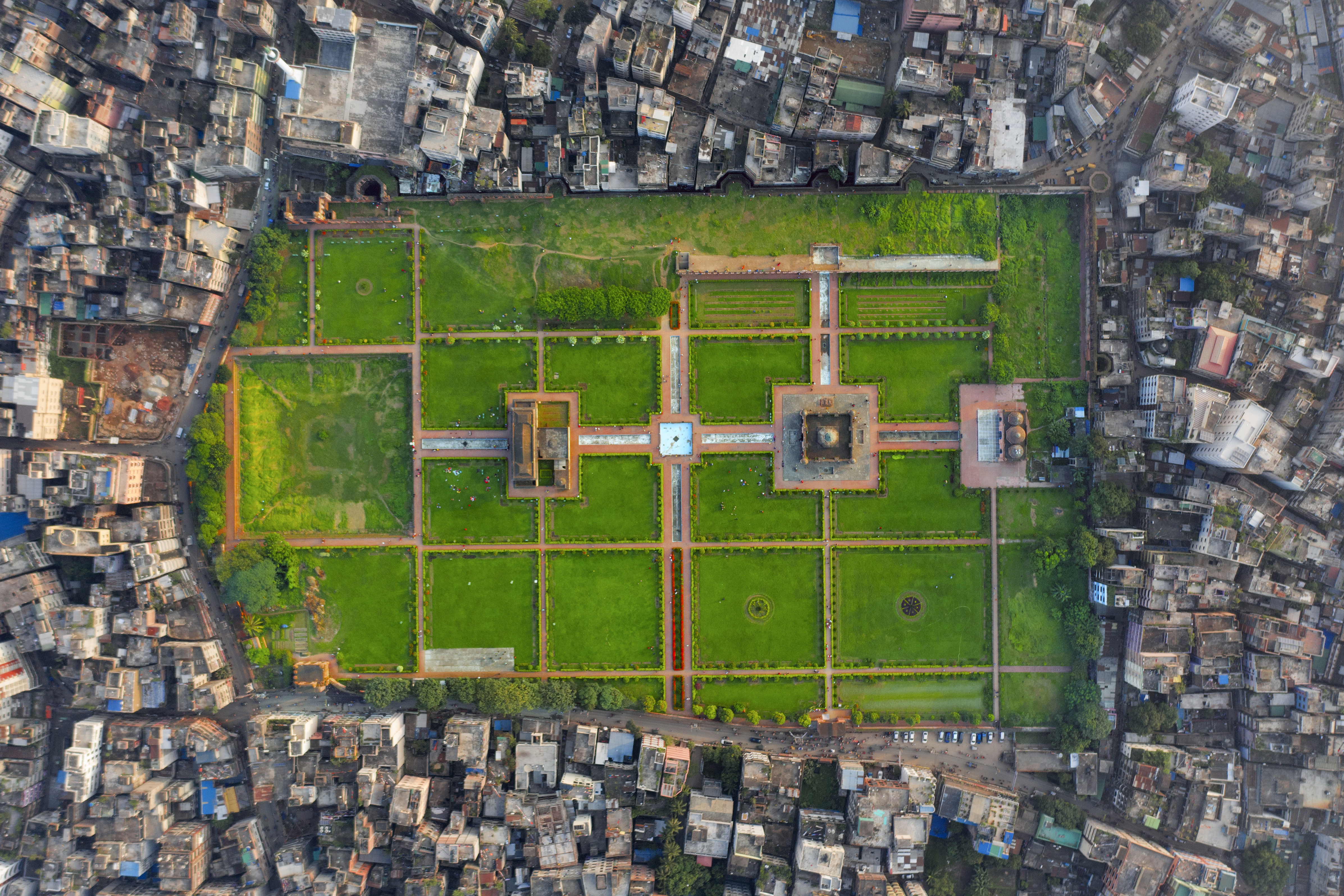
বাংলা: লালবাগের কেল্লা
English: Top view of Lalbagh Qila, Dhaka
|
||
| Date | |||
| Source | Own work | ||
| Author | Pinu Rahman |
| Camera location | | View this and other nearby images on: OpenStreetMap |
|---|
Licensing
I, the copyright holder of this work, hereby publish it under the following licence:
This file is licensed under the Creative Commons Attribution-Share Alike 4.0 International licence.
- You are free:
- to share – to copy, distribute and transmit the work
- to remix – to adapt the work
- Under the following conditions:
- attribution – You must give appropriate credit, provide a link to the licence, and indicate if changes were made. You may do so in any reasonable manner, but not in any way that suggests the licensor endorses you or your use.
- share alike – If you remix, transform, or build upon the material, you must distribute your contributions under the same or compatible licence as the original.

|
This image was uploaded as part of Wiki Loves Monuments 2020.
|
 |
This image was selected as picture of the day on Bengali Wikipedia.
|

|
This image has been assessed under the valued image criteria and is considered the most valued image on Commons within the scope: Arial view of Lalbagh Qila. You can see its nomination here. |
File history
Click on a date/time to view the file as it appeared at that time.
| Date/Time | Thumbnail | Dimensions | User | Comment | |
|---|---|---|---|---|---|
| current | 18:32, 28 November 2020 | | 4,787 × 3,192 (12.07 MB) | wikimediacommons>Pinu Rahman | Uploaded own work with UploadWizard |
File usage
There are no pages that use this file.