1918 map of the Caucasus by the British Army.jpg
From Warlike

Size of this preview: 492 × 599 pixels. Other resolutions: 197 × 240 pixels | 394 × 480 pixels | 630 × 768 pixels | 840 × 1,024 pixels | 1,681 × 2,048 pixels | 6,076 × 7,403 pixels.
Original file (6,076 × 7,403 pixels, file size: 6.44 MB, MIME type: image/jpeg)
Summary
| Description |
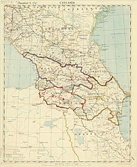
English: 1918 map of the Caucasus by the British Army, with 1919 borders drawn in. |
| Date | and 1919 |
| Source | https://collections.lib.uwm.edu/digital/collection/agdm/id/1715 |
| Author | Great Britain. Army. Royal Engineers. Field Survey Co., 8th |
Licensing
This work created by an employee of the Government of the United Kingdom is in the public domain.
This is because it falls under one (or more) of the following:
HMSO has declared that the expiry of crown copyright applies worldwide (ref: HMSO email reply)
|
 |
File history
Click on a date/time to view the file as it appeared at that time.
| Date/Time | Thumbnail | Dimensions | User | Comment | |
|---|---|---|---|---|---|
| current | 21:28, 8 March 2019 | | 6,076 × 7,403 (6.44 MB) | wikimediacommons>Balkanique | User created page with UploadWizard |