1859 Gibraltar fortifications map.jpg
From Warlike

Size of this preview: 800 × 291 pixels. Other resolutions: 320 × 116 pixels | 640 × 233 pixels | 1,024 × 373 pixels | 1,280 × 466 pixels | 2,560 × 932 pixels | 5,764 × 2,098 pixels.
Original file (5,764 × 2,098 pixels, file size: 4.91 MB, MIME type: image/jpeg)
Summary
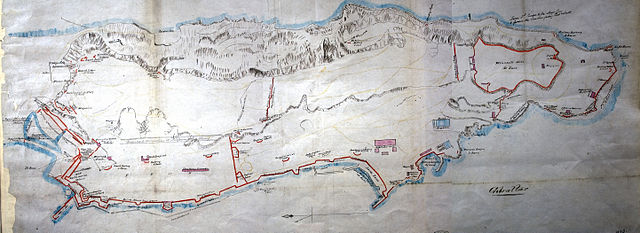
| Description | 'Gibraltar': plan showing naval and military establishments, bastions, batteries and other defence works, magazines. Scale: 6 inches to 2,400 feet |
| Date | |
| Source | UK National Archives MPH 1/23 |
| Author | Unknown author |
Licensing
|
This is a faithful photographic reproduction of a two-dimensional, public domain work of art. The work of art itself is in the public domain for the following reason:
The official position taken by the Wikimedia Foundation is that "faithful reproductions of two-dimensional public domain works of art are public domain".
This photographic reproduction is therefore also considered to be in the public domain in the United States. In other jurisdictions, re-use of this content may be restricted; see Reuse of PD-Art photographs for details. | ||||
File history
Click on a date/time to view the file as it appeared at that time.
| Date/Time | Thumbnail | Dimensions | User | Comment | |
|---|---|---|---|---|---|
| current | 19:02, 12 May 2013 | 5,764 × 2,098 (4.91 MB) | wikimediacommons>Prioryman | {{Information |Description='Gibraltar': plan showing naval and military establishments, bastions, batteries and other defence works, magazines. Scale: 6 inches to 2,400 feet |Source=UK National Archives MPH 1/23 |Date=1859 |Author=Unknown |Permission... |
File usage
There are no pages that use this file.